You are here: Home > Network List > BK - Berkeley Digital Seismograph Network Stations List
> Station HUMO Hull Mountain, OR > Earthquake Result Viewer
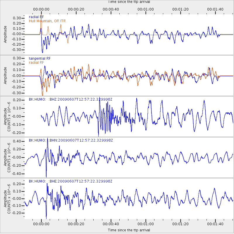
HUMO Hull Mountain, OR - Earthquake Result Viewer
*The percent match for this event was below the threshold and hence no stack was calculated.
| Earthquake location: |
South Of Fiji Islands |
| Earthquake latitude/longitude: |
-22.0/-179.6 |
| Earthquake time(UTC): |
2009/06/07 (158) 12:46:30 GMT |
| Earthquake Depth: |
590 km |
| Earthquake Magnitude: |
5.5 MW, 5.1 MB |
| Earthquake Catalog/Contributor: |
WHDF/NEIC |
|
| Network: |
BK Berkeley Digital Seismograph Network |
| Station: |
HUMO Hull Mountain, OR |
| Lat/Lon: |
42.61 N/122.96 W |
| Elevation: |
555 m |
|
| Distance: |
82.8 deg |
| Az: |
38.42 deg |
| Baz: |
231.349 deg |
| Ray Param: |
$rayparam |
*The percent match for this event was below the threshold and hence was not used in the summary stack. |
|
| Radial Match: |
47.81146 % |
| Radial Bump: |
400 |
| Transverse Match: |
59.71742 % |
| Transverse Bump: |
400 |
| SOD ConfigId: |
2648 |
| Insert Time: |
2010-03-05 19:27:44.022 +0000 |
| GWidth: |
2.5 |
| Max Bumps: |
400 |
| Tol: |
0.001 |
|
Signal To Noise
| Channel | StoN | STA | LTA |
| BK:HUMO: :BHN:20090607T12:57:22.329998Z | 2.1186562 | 1.8626807E-7 | 8.7918025E-8 |
| BK:HUMO: :BHE:20090607T12:57:22.329998Z | 1.3490008 | 8.8890026E-8 | 6.589324E-8 |
| BK:HUMO: :BHZ:20090607T12:57:22.329998Z | 1.6514002 | 9.13944E-8 | 5.5343577E-8 |
| Arrivals |
| Ps | |
| PpPs | |
| PsPs/PpSs | |


