You are here: Home > Network List > BK - Berkeley Digital Seismograph Network Stations List
> Station HUMO Hull Mountain, OR > Earthquake Result Viewer
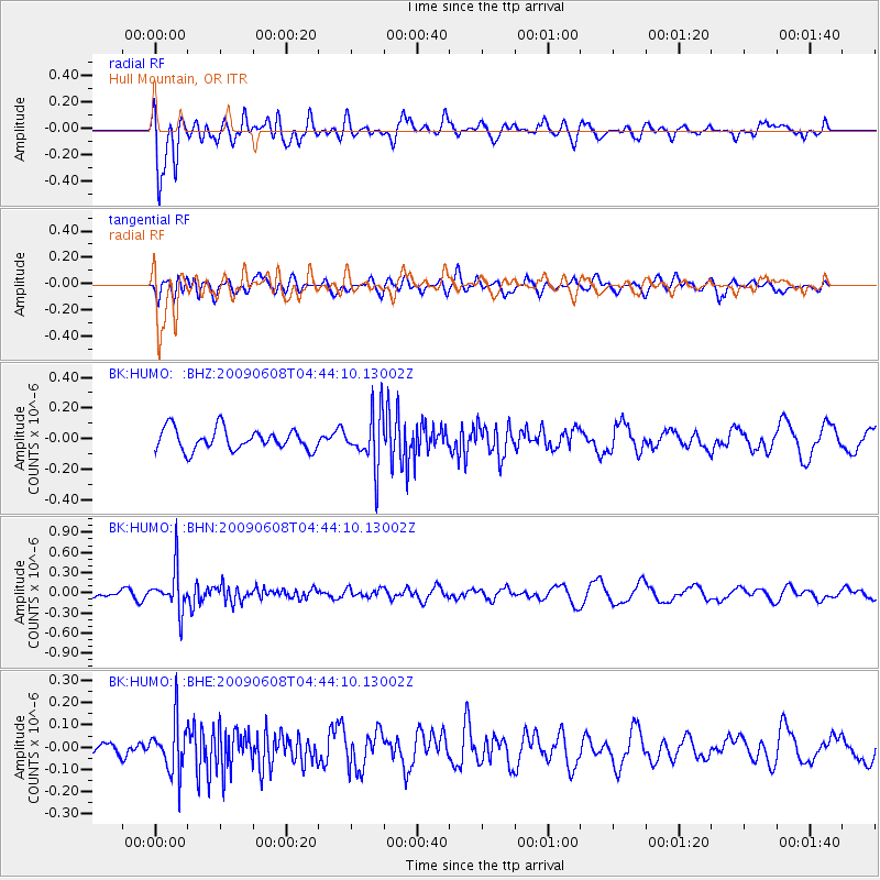
HUMO Hull Mountain, OR - Earthquake Result Viewer
*The percent match for this event was below the threshold and hence no stack was calculated.
| Earthquake location: |
South Of Fiji Islands |
| Earthquake latitude/longitude: |
-22.2/-179.6 |
| Earthquake time(UTC): |
2009/06/08 (159) 04:33:19 GMT |
| Earthquake Depth: |
612 km |
| Earthquake Magnitude: |
5.5 MW, 5.2 MB |
| Earthquake Catalog/Contributor: |
WHDF/NEIC |
|
| Network: |
BK Berkeley Digital Seismograph Network |
| Station: |
HUMO Hull Mountain, OR |
| Lat/Lon: |
42.61 N/122.96 W |
| Elevation: |
555 m |
|
| Distance: |
83.0 deg |
| Az: |
38.419 deg |
| Baz: |
231.248 deg |
| Ray Param: |
$rayparam |
*The percent match for this event was below the threshold and hence was not used in the summary stack. |
|
| Radial Match: |
67.62199 % |
| Radial Bump: |
400 |
| Transverse Match: |
63.6782 % |
| Transverse Bump: |
400 |
| SOD ConfigId: |
2648 |
| Insert Time: |
2010-03-05 19:27:46.116 +0000 |
| GWidth: |
2.5 |
| Max Bumps: |
400 |
| Tol: |
0.001 |
|
Signal To Noise
| Channel | StoN | STA | LTA |
| BK:HUMO: :BHN:20090608T04:44:10.13002Z | 3.058694 | 3.1091975E-7 | 1.01651146E-7 |
| BK:HUMO: :BHE:20090608T04:44:10.13002Z | 2.1379619 | 1.1315128E-7 | 5.2924836E-8 |
| BK:HUMO: :BHZ:20090608T04:44:10.13002Z | 2.4696505 | 1.7084056E-7 | 6.917601E-8 |
| Arrivals |
| Ps | |
| PpPs | |
| PsPs/PpSs | |


