You are here: Home > Network List > BK - Berkeley Digital Seismograph Network Stations List
> Station HUMO Hull Mountain, OR > Earthquake Result Viewer
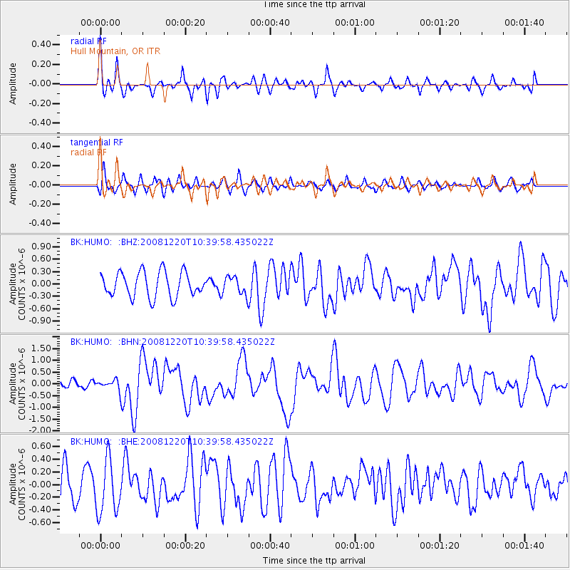
HUMO Hull Mountain, OR - Earthquake Result Viewer
*The percent match for this event was below the threshold and hence no stack was calculated.
| Earthquake location: |
Off East Coast Of Honshu, Japan |
| Earthquake latitude/longitude: |
36.5/142.4 |
| Earthquake time(UTC): |
2008/12/20 (355) 10:29:23 GMT |
| Earthquake Depth: |
19 km |
| Earthquake Magnitude: |
6.0 MB, 6.3 MS, 6.3 MW, 6.3 MW |
| Earthquake Catalog/Contributor: |
WHDF/NEIC |
|
| Network: |
BK Berkeley Digital Seismograph Network |
| Station: |
HUMO Hull Mountain, OR |
| Lat/Lon: |
42.61 N/122.96 W |
| Elevation: |
555 m |
|
| Distance: |
69.4 deg |
| Az: |
51.831 deg |
| Baz: |
300.951 deg |
| Ray Param: |
$rayparam |
*The percent match for this event was below the threshold and hence was not used in the summary stack. |
|
| Radial Match: |
79.60069 % |
| Radial Bump: |
400 |
| Transverse Match: |
61.548218 % |
| Transverse Bump: |
400 |
| SOD ConfigId: |
2658 |
| Insert Time: |
2010-03-05 19:27:59.444 +0000 |
| GWidth: |
2.5 |
| Max Bumps: |
400 |
| Tol: |
0.001 |
|
Signal To Noise
| Channel | StoN | STA | LTA |
| BK:HUMO: :BHN:20081220T10:39:58.435022Z | 1.0824966 | 2.2826835E-7 | 2.108721E-7 |
| BK:HUMO: :BHE:20081220T10:39:58.435022Z | 1.8915256 | 4.313906E-7 | 2.2806489E-7 |
| BK:HUMO: :BHZ:20081220T10:39:58.435022Z | 0.72237134 | 2.1894454E-7 | 3.0309138E-7 |
| Arrivals |
| Ps | |
| PpPs | |
| PsPs/PpSs | |


