You are here: Home > Network List > BK - Berkeley Digital Seismograph Network Stations List
> Station HUMO Hull Mountain, OR > Earthquake Result Viewer
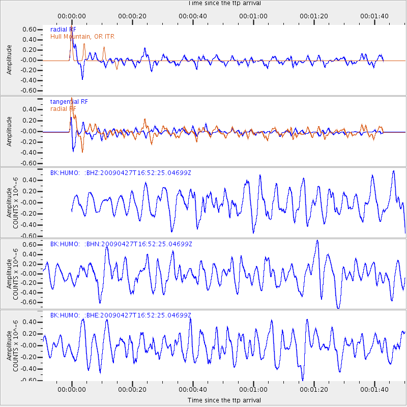
HUMO Hull Mountain, OR - Earthquake Result Viewer
*The percent match for this event was below the threshold and hence no stack was calculated.
| Earthquake location: |
Guerrero, Mexico |
| Earthquake latitude/longitude: |
17.0/-99.4 |
| Earthquake time(UTC): |
2009/04/27 (117) 16:46:28 GMT |
| Earthquake Depth: |
35 km |
| Earthquake Magnitude: |
5.7 MB, 5.4 MS, 5.8 MW, 5.8 MW |
| Earthquake Catalog/Contributor: |
WHDF/NEIC |
|
| Network: |
BK Berkeley Digital Seismograph Network |
| Station: |
HUMO Hull Mountain, OR |
| Lat/Lon: |
42.61 N/122.96 W |
| Elevation: |
555 m |
|
| Distance: |
32.4 deg |
| Az: |
326.692 deg |
| Baz: |
134.634 deg |
| Ray Param: |
$rayparam |
*The percent match for this event was below the threshold and hence was not used in the summary stack. |
|
| Radial Match: |
64.88961 % |
| Radial Bump: |
400 |
| Transverse Match: |
50.049015 % |
| Transverse Bump: |
400 |
| SOD ConfigId: |
2658 |
| Insert Time: |
2010-03-05 19:28:01.056 +0000 |
| GWidth: |
2.5 |
| Max Bumps: |
400 |
| Tol: |
0.001 |
|
Signal To Noise
| Channel | StoN | STA | LTA |
| BK:HUMO: :BHN:20090427T16:52:25.04699Z | 0.79538727 | 1.2431622E-7 | 1.5629647E-7 |
| BK:HUMO: :BHE:20090427T16:52:25.04699Z | 2.2483907 | 2.4480468E-7 | 1.0887995E-7 |
| BK:HUMO: :BHZ:20090427T16:52:25.04699Z | 1.8115675 | 2.6594168E-7 | 1.4680197E-7 |
| Arrivals |
| Ps | |
| PpPs | |
| PsPs/PpSs | |


