You are here: Home > Network List > BK - Berkeley Digital Seismograph Network Stations List
> Station HUMO Hull Mountain, OR > Earthquake Result Viewer
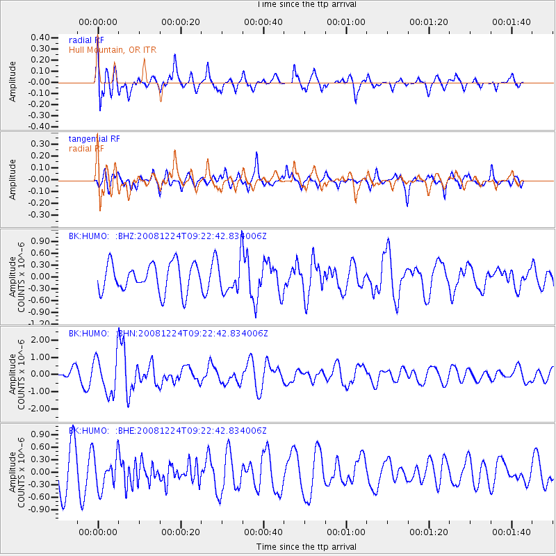
HUMO Hull Mountain, OR - Earthquake Result Viewer
*The percent match for this event was below the threshold and hence no stack was calculated.
| Earthquake location: |
Tonga Islands Region |
| Earthquake latitude/longitude: |
-17.3/-171.9 |
| Earthquake time(UTC): |
2008/12/24 (359) 09:11:34 GMT |
| Earthquake Depth: |
9.0 km |
| Earthquake Magnitude: |
5.9 MB, 5.6 MS, 6.0 MW, 6.0 MW |
| Earthquake Catalog/Contributor: |
WHDF/NEIC |
|
| Network: |
BK Berkeley Digital Seismograph Network |
| Station: |
HUMO Hull Mountain, OR |
| Lat/Lon: |
42.61 N/122.96 W |
| Elevation: |
555 m |
|
| Distance: |
74.7 deg |
| Az: |
35.257 deg |
| Baz: |
228.331 deg |
| Ray Param: |
$rayparam |
*The percent match for this event was below the threshold and hence was not used in the summary stack. |
|
| Radial Match: |
55.52647 % |
| Radial Bump: |
400 |
| Transverse Match: |
47.623096 % |
| Transverse Bump: |
361 |
| SOD ConfigId: |
2658 |
| Insert Time: |
2010-03-05 19:28:02.076 +0000 |
| GWidth: |
2.5 |
| Max Bumps: |
400 |
| Tol: |
0.001 |
|
Signal To Noise
| Channel | StoN | STA | LTA |
| BK:HUMO: :BHN:20081224T09:22:42.834006Z | 3.4078274 | 1.1420366E-6 | 3.3512163E-7 |
| BK:HUMO: :BHE:20081224T09:22:42.834006Z | 0.89681524 | 3.740709E-7 | 4.1711033E-7 |
| BK:HUMO: :BHZ:20081224T09:22:42.834006Z | 1.204139 | 4.3094627E-7 | 3.578875E-7 |
| Arrivals |
| Ps | |
| PpPs | |
| PsPs/PpSs | |


