You are here: Home > Network List > BK - Berkeley Digital Seismograph Network Stations List
> Station HUMO Hull Mountain, OR > Earthquake Result Viewer
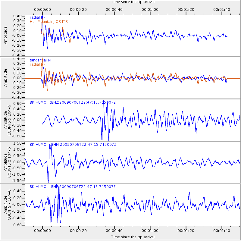
HUMO Hull Mountain, OR - Earthquake Result Viewer
*The percent match for this event was below the threshold and hence no stack was calculated.
| Earthquake location: |
Southeast Of Ryukyu Islands |
| Earthquake latitude/longitude: |
24.9/128.0 |
| Earthquake time(UTC): |
2009/07/06 (187) 22:35:05 GMT |
| Earthquake Depth: |
10 km |
| Earthquake Magnitude: |
6.1 MB, 5.3 MS, 5.7 MW, 5.7 MW |
| Earthquake Catalog/Contributor: |
WHDF/NEIC |
|
| Network: |
BK Berkeley Digital Seismograph Network |
| Station: |
HUMO Hull Mountain, OR |
| Lat/Lon: |
42.61 N/122.96 W |
| Elevation: |
555 m |
|
| Distance: |
86.4 deg |
| Az: |
44.379 deg |
| Baz: |
300.629 deg |
| Ray Param: |
$rayparam |
*The percent match for this event was below the threshold and hence was not used in the summary stack. |
|
| Radial Match: |
80.7004 % |
| Radial Bump: |
400 |
| Transverse Match: |
70.863464 % |
| Transverse Bump: |
400 |
| SOD ConfigId: |
2648 |
| Insert Time: |
2010-03-05 19:28:04.230 +0000 |
| GWidth: |
2.5 |
| Max Bumps: |
400 |
| Tol: |
0.001 |
|
Signal To Noise
| Channel | StoN | STA | LTA |
| BK:HUMO: :BHN:20090706T22:47:15.715007Z | 6.156358 | 7.377182E-7 | 1.198303E-7 |
| BK:HUMO: :BHE:20090706T22:47:15.715007Z | 2.4980235 | 1.7401047E-7 | 6.965926E-8 |
| BK:HUMO: :BHZ:20090706T22:47:15.715007Z | 2.97946 | 3.0860147E-7 | 1.03576305E-7 |
| Arrivals |
| Ps | |
| PpPs | |
| PsPs/PpSs | |


