You are here: Home > Network List > BK - Berkeley Digital Seismograph Network Stations List
> Station HUMO Hull Mountain, OR > Earthquake Result Viewer
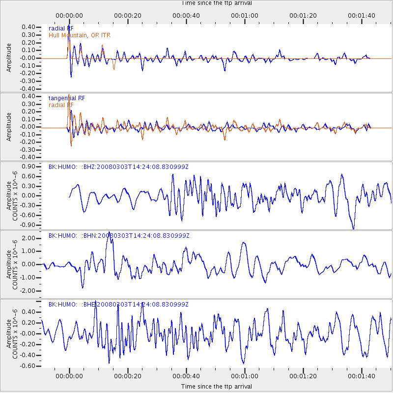
HUMO Hull Mountain, OR - Earthquake Result Viewer
*The percent match for this event was below the threshold and hence no stack was calculated.
| Earthquake location: |
Philippine Islands Region |
| Earthquake latitude/longitude: |
13.4/125.6 |
| Earthquake time(UTC): |
2008/03/03 (063) 14:11:14 GMT |
| Earthquake Depth: |
24 km |
| Earthquake Magnitude: |
6.4 MB, 6.9 MW, 6.8 MW |
| Earthquake Catalog/Contributor: |
WHDF/NEIC |
|
| Network: |
BK Berkeley Digital Seismograph Network |
| Station: |
HUMO Hull Mountain, OR |
| Lat/Lon: |
42.61 N/122.96 W |
| Elevation: |
555 m |
|
| Distance: |
96.2 deg |
| Az: |
43.735 deg |
| Baz: |
294.297 deg |
| Ray Param: |
$rayparam |
*The percent match for this event was below the threshold and hence was not used in the summary stack. |
|
| Radial Match: |
77.44361 % |
| Radial Bump: |
400 |
| Transverse Match: |
53.24405 % |
| Transverse Bump: |
400 |
| SOD ConfigId: |
2504 |
| Insert Time: |
2010-03-05 19:28:10.860 +0000 |
| GWidth: |
2.5 |
| Max Bumps: |
400 |
| Tol: |
0.001 |
|
Signal To Noise
| Channel | StoN | STA | LTA |
| BK:HUMO: :BHN:20080303T14:24:08.830999Z | 3.8355308 | 6.482598E-7 | 1.6901436E-7 |
| BK:HUMO: :BHE:20080303T14:24:08.830999Z | 0.7191377 | 1.1732173E-7 | 1.6314223E-7 |
| BK:HUMO: :BHZ:20080303T14:24:08.830999Z | 1.0686027 | 2.0829033E-7 | 1.9491841E-7 |
| Arrivals |
| Ps | |
| PpPs | |
| PsPs/PpSs | |


