You are here: Home > Network List > GS - US Geological Survey Networks Stations List
> Station OK031 2598 S. Brethren Rd., Cushing, OK, USA > Earthquake Result Viewer
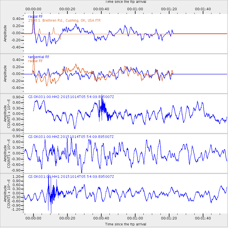
OK031 2598 S. Brethren Rd., Cushing, OK, USA - Earthquake Result Viewer
*The percent match for this event was below the threshold and hence no stack was calculated.
| Earthquake location: |
East Of Kuril Islands |
| Earthquake latitude/longitude: |
48.9/156.2 |
| Earthquake time(UTC): |
2015/10/14 (287) 05:43:07 GMT |
| Earthquake Depth: |
6.0 km |
| Earthquake Magnitude: |
5.6 MB, 5.9 MWB |
| Earthquake Catalog/Contributor: |
NEIC PDE/NEIC COMCAT |
|
| Network: |
GS US Geological Survey Networks |
| Station: |
OK031 2598 S. Brethren Rd., Cushing, OK, USA |
| Lat/Lon: |
35.95 N/96.84 W |
| Elevation: |
290 m |
|
| Distance: |
73.6 deg |
| Az: |
54.032 deg |
| Baz: |
318.786 deg |
| Ray Param: |
$rayparam |
*The percent match for this event was below the threshold and hence was not used in the summary stack. |
|
| Radial Match: |
54.346104 % |
| Radial Bump: |
400 |
| Transverse Match: |
34.135937 % |
| Transverse Bump: |
400 |
| SOD ConfigId: |
1259291 |
| Insert Time: |
2015-10-28 06:48:48.962 +0000 |
| GWidth: |
2.5 |
| Max Bumps: |
400 |
| Tol: |
0.001 |
|
Signal To Noise
| Channel | StoN | STA | LTA |
| GS:OK031:00:HHZ:20151014T05:54:09.895007Z | 2.2152574 | 3.485557E-7 | 1.573432E-7 |
| GS:OK031:00:HH1:20151014T05:54:09.895007Z | 1.8340582 | 3.4811913E-7 | 1.898081E-7 |
| GS:OK031:00:HH2:20151014T05:54:09.895007Z | 0.4767453 | 1.7711096E-7 | 3.7150016E-7 |
| Arrivals |
| Ps | |
| PpPs | |
| PsPs/PpSs | |


