You are here: Home > Network List > 8G - 2016 Pedernales Earthquake Aftershock Deployment Ecuador Stations List
> Station EC04 EC04 > Earthquake Result Viewer
EC04 EC04 - Earthquake Result Viewer
| Earthquake location: |
Chile-Argentina Border Region |
| Earthquake latitude/longitude: |
-35.1/-71.0 |
| Earthquake time(UTC): |
2016/11/04 (309) 16:20:43 GMT |
| Earthquake Depth: |
91 km |
| Earthquake Magnitude: |
6.4 MWP, 6.4 MWW |
| Earthquake Catalog/Contributor: |
NEIC PDE/NEIC COMCAT |
|
| Network: |
8G 2016 Pedernales Earthquake Aftershock Deployment Ecuador |
| Station: |
EC04 EC04 |
| Lat/Lon: |
0.29 N/79.61 W |
| Elevation: |
128 m |
|
| Distance: |
36.1 deg |
| Az: |
345.274 deg |
| Baz: |
167.97 deg |
| Ray Param: |
0.07656748 |
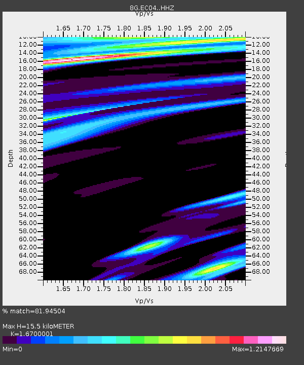
| Estimated Moho Depth: |
15.5 km |
| Estimated Crust Vp/Vs: |
1.67 |
| Assumed Crust Vp: |
6.472 km/s |
| Estimated Crust Vs: |
3.875 km/s |
| Estimated Crust Poisson's Ratio: |
0.22 |
|
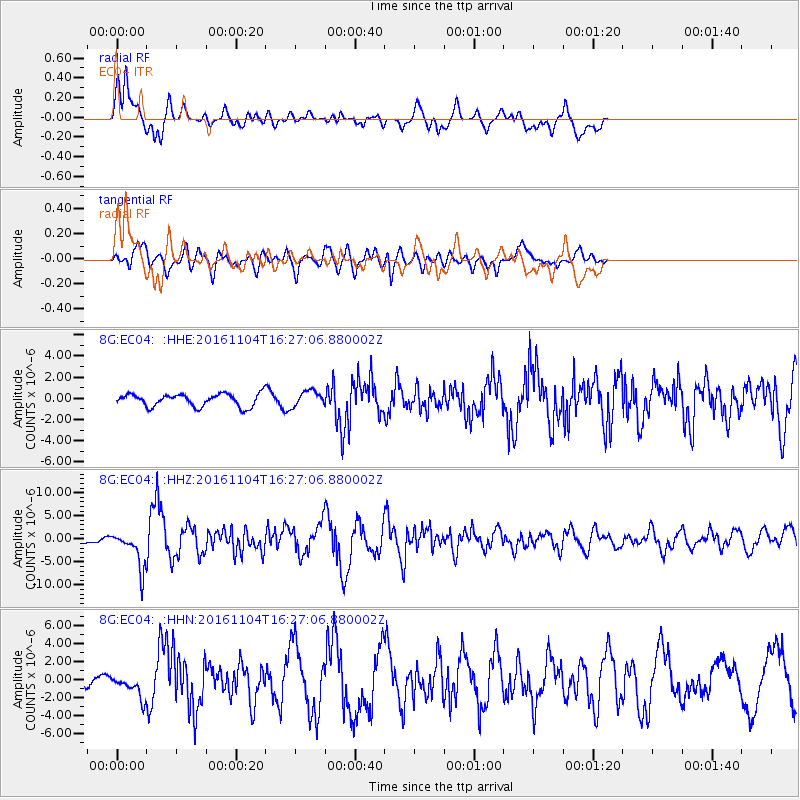
| Radial Match: |
81.94504 % |
| Radial Bump: |
400 |
| Transverse Match: |
73.976616 % |
| Transverse Bump: |
400 |
| SOD ConfigId: |
11737051 |
| Insert Time: |
2019-04-26 00:13:35.426 +0000 |
| GWidth: |
2.5 |
| Max Bumps: |
400 |
| Tol: |
0.001 |
|
Signal To Noise
| Channel | StoN | STA | LTA |
| 8G:EC04: :HHZ:20161104T16:27:06.880002Z | 10.16125 | 3.961171E-6 | 3.8983103E-7 |
| 8G:EC04: :HHN:20161104T16:27:06.880002Z | 3.1853442 | 1.2436951E-6 | 3.9044295E-7 |
| 8G:EC04: :HHE:20161104T16:27:06.880002Z | 1.2614462 | 7.4869047E-7 | 5.935175E-7 |
| Arrivals |
| Ps | 1.7 SECOND |
| PpPs | 5.9 SECOND |
| PsPs/PpSs | 7.6 SECOND |


