You are here: Home > Network List > 8G - 2016 Pedernales Earthquake Aftershock Deployment Ecuador Stations List
> Station EC11 EC11 > Earthquake Result Viewer
EC11 EC11 - Earthquake Result Viewer
| Earthquake location: |
Chile-Argentina Border Region |
| Earthquake latitude/longitude: |
-35.1/-71.0 |
| Earthquake time(UTC): |
2016/11/04 (309) 16:20:43 GMT |
| Earthquake Depth: |
91 km |
| Earthquake Magnitude: |
6.4 MWP, 6.4 MWW |
| Earthquake Catalog/Contributor: |
NEIC PDE/NEIC COMCAT |
|
| Network: |
8G 2016 Pedernales Earthquake Aftershock Deployment Ecuador |
| Station: |
EC11 EC11 |
| Lat/Lon: |
0.81 N/79.86 W |
| Elevation: |
33 m |
|
| Distance: |
36.7 deg |
| Az: |
345.049 deg |
| Baz: |
167.786 deg |
| Ray Param: |
0.076263554 |
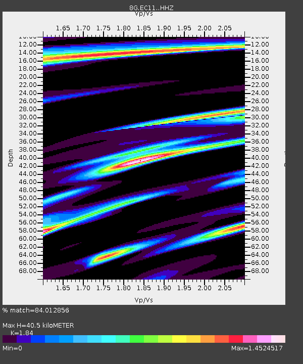
| Estimated Moho Depth: |
40.5 km |
| Estimated Crust Vp/Vs: |
1.84 |
| Assumed Crust Vp: |
6.472 km/s |
| Estimated Crust Vs: |
3.517 km/s |
| Estimated Crust Poisson's Ratio: |
0.29 |
|
| Radial Match: |
84.012856 % |
| Radial Bump: |
378 |
| Transverse Match: |
71.24283 % |
| Transverse Bump: |
392 |
| SOD ConfigId: |
11737051 |
| Insert Time: |
2019-04-26 00:13:38.768 +0000 |
| GWidth: |
2.5 |
| Max Bumps: |
400 |
| Tol: |
0.001 |
|

Signal To Noise
| Channel | StoN | STA | LTA |
| 8G:EC11: :HHZ:20161104T16:27:11.644987Z | 9.348693 | 3.7646516E-6 | 4.0269282E-7 |
| 8G:EC11: :HHN:20161104T16:27:11.644987Z | 2.562178 | 1.5176222E-6 | 5.923173E-7 |
| 8G:EC11: :HHE:20161104T16:27:11.644987Z | 1.0579077 | 7.244918E-7 | 6.848346E-7 |
| Arrivals |
| Ps | 5.6 SECOND |
| PpPs | 17 SECOND |
| PsPs/PpSs | 22 SECOND |


