You are here: Home > Network List > 8G - 2016 Pedernales Earthquake Aftershock Deployment Ecuador Stations List
> Station EC18 EC18 > Earthquake Result Viewer
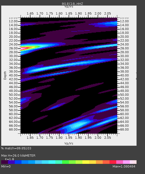
EC18 EC18 - Earthquake Result Viewer
| Earthquake location: |
Chile-Argentina Border Region |
| Earthquake latitude/longitude: |
-35.1/-71.0 |
| Earthquake time(UTC): |
2016/11/04 (309) 16:20:43 GMT |
| Earthquake Depth: |
91 km |
| Earthquake Magnitude: |
6.4 MWP, 6.4 MWW |
| Earthquake Catalog/Contributor: |
NEIC PDE/NEIC COMCAT |
|
| Network: |
8G 2016 Pedernales Earthquake Aftershock Deployment Ecuador |
| Station: |
EC18 EC18 |
| Lat/Lon: |
0.21 S/80.18 W |
| Elevation: |
243 m |
|
| Distance: |
35.8 deg |
| Az: |
344.153 deg |
| Baz: |
167.062 deg |
| Ray Param: |
0.076766245 |
| Estimated Moho Depth: |
26.0 km |
| Estimated Crust Vp/Vs: |
1.60 |
| Assumed Crust Vp: |
6.183 km/s |
| Estimated Crust Vs: |
3.864 km/s |
| Estimated Crust Poisson's Ratio: |
0.18 |
|
| Radial Match: |
89.85103 % |
| Radial Bump: |
400 |
| Transverse Match: |
79.48371 % |
| Transverse Bump: |
400 |
| SOD ConfigId: |
11737051 |
| Insert Time: |
2019-04-26 00:13:41.715 +0000 |
| GWidth: |
2.5 |
| Max Bumps: |
400 |
| Tol: |
0.001 |
|

Signal To Noise
| Channel | StoN | STA | LTA |
| 8G:EC18: :HHZ:20161104T16:27:03.755002Z | 26.031641 | 3.2608702E-6 | 1.2526564E-7 |
| 8G:EC18: :HHN:20161104T16:27:03.755002Z | 16.95232 | 1.8725606E-6 | 1.10460434E-7 |
| 8G:EC18: :HHE:20161104T16:27:03.755002Z | 8.039803 | 7.7867577E-7 | 9.68526E-8 |
| Arrivals |
| Ps | 2.7 SECOND |
| PpPs | 10 SECOND |
| PsPs/PpSs | 13 SECOND |


