You are here: Home > Network List > AG - Arkansas Seismic Network Stations List
> Station U40A Yellville, AR > Earthquake Result Viewer
U40A Yellville, AR - Earthquake Result Viewer
| Earthquake location: |
Chile-Argentina Border Region |
| Earthquake latitude/longitude: |
-35.1/-71.0 |
| Earthquake time(UTC): |
2016/11/04 (309) 16:20:43 GMT |
| Earthquake Depth: |
91 km |
| Earthquake Magnitude: |
6.4 MWP, 6.4 MWW |
| Earthquake Catalog/Contributor: |
NEIC PDE/NEIC COMCAT |
|
| Network: |
AG Arkansas Seismic Network |
| Station: |
U40A Yellville, AR |
| Lat/Lon: |
36.36 N/92.85 W |
| Elevation: |
374 m |
|
| Distance: |
74.0 deg |
| Az: |
341.777 deg |
| Baz: |
161.48 deg |
| Ray Param: |
0.05244618 |
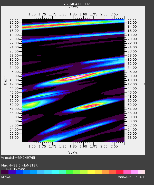
| Estimated Moho Depth: |
38.5 km |
| Estimated Crust Vp/Vs: |
1.86 |
| Assumed Crust Vp: |
6.53 km/s |
| Estimated Crust Vs: |
3.516 km/s |
| Estimated Crust Poisson's Ratio: |
0.30 |
|
| Radial Match: |
89.149765 % |
| Radial Bump: |
361 |
| Transverse Match: |
63.217888 % |
| Transverse Bump: |
400 |
| SOD ConfigId: |
11737051 |
| Insert Time: |
2019-04-26 00:13:54.179 +0000 |
| GWidth: |
2.5 |
| Max Bumps: |
400 |
| Tol: |
0.001 |
|
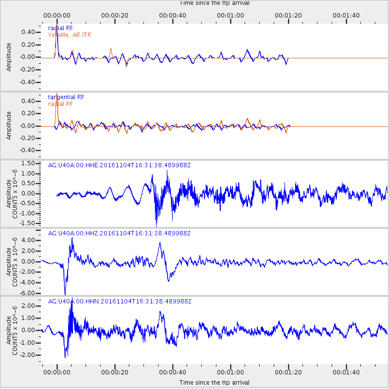
Signal To Noise
| Channel | StoN | STA | LTA |
| AG:U40A:00:HHZ:20161104T16:31:38.489988Z | 13.06234 | 2.206932E-6 | 1.6895382E-7 |
| AG:U40A:00:HHN:20161104T16:31:38.489988Z | 5.8716483 | 8.481201E-7 | 1.4444328E-7 |
| AG:U40A:00:HHE:20161104T16:31:38.489988Z | 3.6239355 | 5.127108E-7 | 1.41479E-7 |
| Arrivals |
| Ps | 5.2 SECOND |
| PpPs | 16 SECOND |
| PsPs/PpSs | 22 SECOND |


