You are here: Home > Network List > II - Global Seismograph Network (GSN - IRIS/IDA) Stations List
> Station NIL Nilore, Pakistan > Earthquake Result Viewer
NIL Nilore, Pakistan - Earthquake Result Viewer

| Earthquake location: |
East Of Kuril Islands |
| Earthquake latitude/longitude: |
48.9/156.2 |
| Earthquake time(UTC): |
2015/10/14 (287) 05:43:07 GMT |
| Earthquake Depth: |
6.0 km |
| Earthquake Magnitude: |
5.6 MB, 5.9 MWB |
| Earthquake Catalog/Contributor: |
NEIC PDE/NEIC COMCAT |
|
| Network: |
II Global Seismograph Network (GSN - IRIS/IDA) |
| Station: |
NIL Nilore, Pakistan |
| Lat/Lon: |
33.65 N/73.27 E |
| Elevation: |
629 m |
|
| Distance: |
61.2 deg |
| Az: |
289.166 deg |
| Baz: |
48.414 deg |
| Ray Param: |
0.061024617 |
| Estimated Moho Depth: |
13.0 km |
| Estimated Crust Vp/Vs: |
1.64 |
| Assumed Crust Vp: |
6.242 km/s |
| Estimated Crust Vs: |
3.806 km/s |
| Estimated Crust Poisson's Ratio: |
0.20 |
|
| Radial Match: |
91.47508 % |
| Radial Bump: |
400 |
| Transverse Match: |
81.658806 % |
| Transverse Bump: |
400 |
| SOD ConfigId: |
1259291 |
| Insert Time: |
2015-10-28 06:50:13.076 +0000 |
| GWidth: |
2.5 |
| Max Bumps: |
400 |
| Tol: |
0.001 |
|
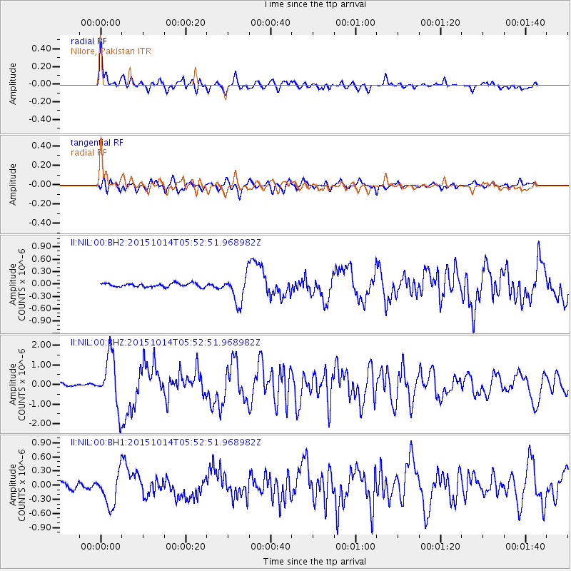
Signal To Noise
| Channel | StoN | STA | LTA |
| II:NIL:00:BHZ:20151014T05:52:51.968982Z | 16.032534 | 1.3606214E-6 | 8.486627E-8 |
| II:NIL:00:BH1:20151014T05:52:51.968982Z | 5.4991593 | 3.63592E-7 | 6.611774E-8 |
| II:NIL:00:BH2:20151014T05:52:51.968982Z | 8.1354 | 3.5174887E-7 | 4.3236824E-8 |
| Arrivals |
| Ps | 1.4 SECOND |
| PpPs | 5.2 SECOND |
| PsPs/PpSs | 6.6 SECOND |


