You are here: Home > Network List > N4 - Central and EAstern US Network Stations List
> Station F33B 5 Mile Ranch, Herman, MN, USA > Earthquake Result Viewer
F33B 5 Mile Ranch, Herman, MN, USA - Earthquake Result Viewer
| Earthquake location: |
Chile-Argentina Border Region |
| Earthquake latitude/longitude: |
-35.1/-71.0 |
| Earthquake time(UTC): |
2016/11/04 (309) 16:20:43 GMT |
| Earthquake Depth: |
91 km |
| Earthquake Magnitude: |
6.4 MWP, 6.4 MWW |
| Earthquake Catalog/Contributor: |
NEIC PDE/NEIC COMCAT |
|
| Network: |
N4 Central and EAstern US Network |
| Station: |
F33B 5 Mile Ranch, Herman, MN, USA |
| Lat/Lon: |
45.84 N/96.29 W |
| Elevation: |
314 m |
|
| Distance: |
83.7 deg |
| Az: |
342.512 deg |
| Baz: |
159.363 deg |
| Ray Param: |
0.04577431 |
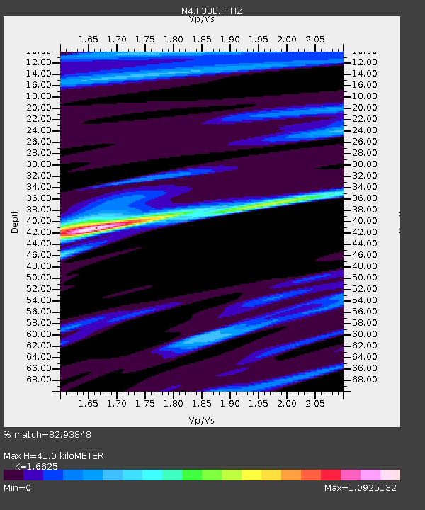
| Estimated Moho Depth: |
41.0 km |
| Estimated Crust Vp/Vs: |
1.66 |
| Assumed Crust Vp: |
6.552 km/s |
| Estimated Crust Vs: |
3.941 km/s |
| Estimated Crust Poisson's Ratio: |
0.22 |
|
| Radial Match: |
82.93848 % |
| Radial Bump: |
400 |
| Transverse Match: |
79.295654 % |
| Transverse Bump: |
400 |
| SOD ConfigId: |
11737051 |
| Insert Time: |
2019-04-26 00:17:06.368 +0000 |
| GWidth: |
2.5 |
| Max Bumps: |
400 |
| Tol: |
0.001 |
|

Signal To Noise
| Channel | StoN | STA | LTA |
| N4:F33B: :HHZ:20161104T16:32:31.859983Z | 11.670668 | 1.8781271E-6 | 1.6092713E-7 |
| N4:F33B: :HHN:20161104T16:32:31.859983Z | 4.2802844 | 8.0420045E-7 | 1.8788482E-7 |
| N4:F33B: :HHE:20161104T16:32:31.859983Z | 1.6350644 | 2.3327534E-7 | 1.4267044E-7 |
| Arrivals |
| Ps | 4.3 SECOND |
| PpPs | 16 SECOND |
| PsPs/PpSs | 20 SECOND |


