You are here: Home > Network List > BK - Berkeley Digital Seismograph Network Stations List
> Station JCC Jacoby Creek, Bayside, CA > Earthquake Result Viewer
JCC Jacoby Creek, Bayside, CA - Earthquake Result Viewer
| Earthquake location: |
Leeward Islands |
| Earthquake latitude/longitude: |
15.7/-61.7 |
| Earthquake time(UTC): |
2004/11/21 (326) 11:41:07 GMT |
| Earthquake Depth: |
14 km |
| Earthquake Magnitude: |
6.3 MB, 6.1 MS, 6.3 MW, 6.3 MW |
| Earthquake Catalog/Contributor: |
WHDF/NEIC |
|
| Network: |
BK Berkeley Digital Seismograph Network |
| Station: |
JCC Jacoby Creek, Bayside, CA |
| Lat/Lon: |
40.82 N/124.03 W |
| Elevation: |
27 m |
|
| Distance: |
59.0 deg |
| Az: |
308.39 deg |
| Baz: |
95.856 deg |
| Ray Param: |
0.062442746 |
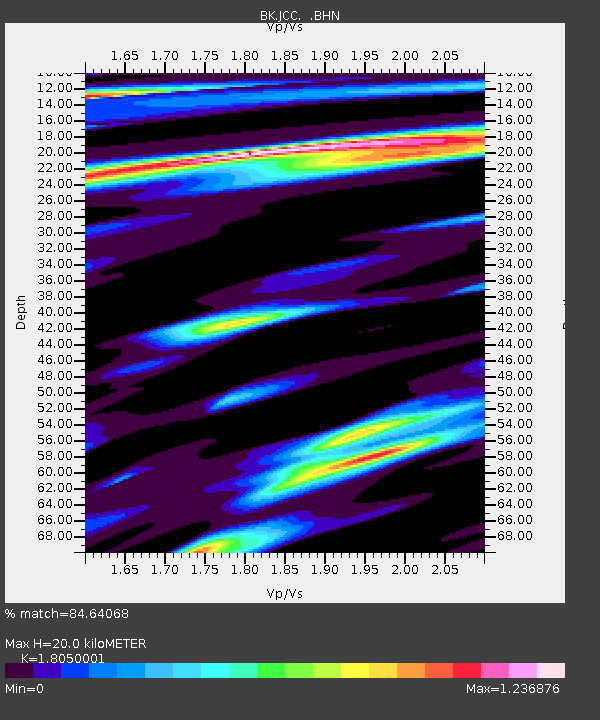
| Estimated Moho Depth: |
20.0 km |
| Estimated Crust Vp/Vs: |
1.81 |
| Assumed Crust Vp: |
6.048 km/s |
| Estimated Crust Vs: |
3.351 km/s |
| Estimated Crust Poisson's Ratio: |
0.28 |
|
| Radial Match: |
84.64068 % |
| Radial Bump: |
400 |
| Transverse Match: |
73.46547 % |
| Transverse Bump: |
400 |
| SOD ConfigId: |
2459 |
| Insert Time: |
2010-03-05 19:30:22.237 +0000 |
| GWidth: |
2.5 |
| Max Bumps: |
400 |
| Tol: |
0.001 |
|
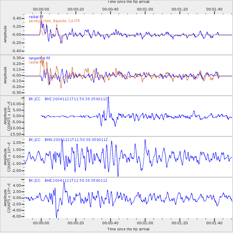
Signal To Noise
| Channel | StoN | STA | LTA |
| BK:JCC: :BHN:20041121T11:50:36.059011Z | 1.1403787 | 4.632731E-7 | 4.0624494E-7 |
| BK:JCC: :BHE:20041121T11:50:36.059011Z | 1.729725 | 8.245989E-7 | 4.7672256E-7 |
| BK:JCC: :BHZ:20041121T11:50:36.059011Z | 5.5631385 | 2.2407528E-6 | 4.027857E-7 |
| Arrivals |
| Ps | 2.8 SECOND |
| PpPs | 8.9 SECOND |
| PsPs/PpSs | 12 SECOND |


