You are here: Home > Network List > SC - New Mexico Tech Seismic Network Stations List
> Station Y22A Socorro, NM, USA > Earthquake Result Viewer
Y22A Socorro, NM, USA - Earthquake Result Viewer
| Earthquake location: |
Chile-Argentina Border Region |
| Earthquake latitude/longitude: |
-35.1/-71.0 |
| Earthquake time(UTC): |
2016/11/04 (309) 16:20:43 GMT |
| Earthquake Depth: |
91 km |
| Earthquake Magnitude: |
6.4 MWP, 6.4 MWW |
| Earthquake Catalog/Contributor: |
NEIC PDE/NEIC COMCAT |
|
| Network: |
SC New Mexico Tech Seismic Network |
| Station: |
Y22A Socorro, NM, USA |
| Lat/Lon: |
33.94 N/106.97 W |
| Elevation: |
1674 m |
|
| Distance: |
76.5 deg |
| Az: |
329.854 deg |
| Baz: |
150.312 deg |
| Ray Param: |
0.050753325 |
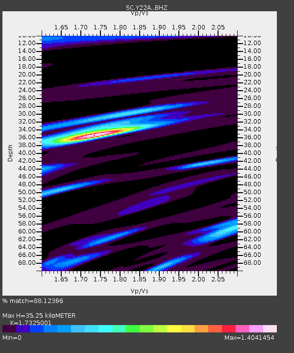
| Estimated Moho Depth: |
35.25 km |
| Estimated Crust Vp/Vs: |
1.73 |
| Assumed Crust Vp: |
6.502 km/s |
| Estimated Crust Vs: |
3.753 km/s |
| Estimated Crust Poisson's Ratio: |
0.25 |
|
| Radial Match: |
88.12396 % |
| Radial Bump: |
400 |
| Transverse Match: |
75.12663 % |
| Transverse Bump: |
400 |
| SOD ConfigId: |
11737051 |
| Insert Time: |
2019-04-26 00:21:07.793 +0000 |
| GWidth: |
2.5 |
| Max Bumps: |
400 |
| Tol: |
0.001 |
|

Signal To Noise
| Channel | StoN | STA | LTA |
| SC:Y22A: :BHZ:20161104T16:31:53.023984Z | 3.9691198 | 1.4912617E-6 | 3.7571596E-7 |
| SC:Y22A: :BHN:20161104T16:31:53.023984Z | 1.262447 | 2.820173E-7 | 2.2338942E-7 |
| SC:Y22A: :BHE:20161104T16:31:53.023984Z | 0.89555466 | 3.8718028E-7 | 4.3233572E-7 |
| Arrivals |
| Ps | 4.1 SECOND |
| PpPs | 14 SECOND |
| PsPs/PpSs | 18 SECOND |


