You are here: Home > Network List > UW - Pacific Northwest Regional Seismic Network Stations List
> Station UMAT Pilot Rock, OR, USA > Earthquake Result Viewer
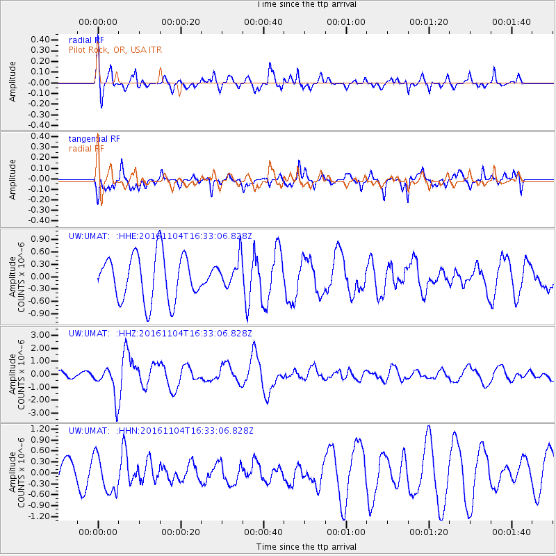
UMAT Pilot Rock, OR, USA - Earthquake Result Viewer
*The percent match for this event was below the threshold and hence no stack was calculated.
| Earthquake location: |
Chile-Argentina Border Region |
| Earthquake latitude/longitude: |
-35.1/-71.0 |
| Earthquake time(UTC): |
2016/11/04 (309) 16:20:43 GMT |
| Earthquake Depth: |
91 km |
| Earthquake Magnitude: |
6.4 MWP, 6.4 MWW |
| Earthquake Catalog/Contributor: |
NEIC PDE/NEIC COMCAT |
|
| Network: |
UW Pacific Northwest Regional Seismic Network |
| Station: |
UMAT Pilot Rock, OR, USA |
| Lat/Lon: |
45.29 N/118.96 W |
| Elevation: |
1318 m |
|
| Distance: |
91.0 deg |
| Az: |
328.375 deg |
| Baz: |
142.478 deg |
| Ray Param: |
$rayparam |
*The percent match for this event was below the threshold and hence was not used in the summary stack. |
|
| Radial Match: |
73.63864 % |
| Radial Bump: |
388 |
| Transverse Match: |
56.879787 % |
| Transverse Bump: |
369 |
| SOD ConfigId: |
11737051 |
| Insert Time: |
2019-04-26 00:22:22.774 +0000 |
| GWidth: |
2.5 |
| Max Bumps: |
400 |
| Tol: |
0.001 |
|
Signal To Noise
| Channel | StoN | STA | LTA |
| UW:UMAT: :HHZ:20161104T16:33:06.828Z | 7.0523987 | 1.2617585E-6 | 1.7891196E-7 |
| UW:UMAT: :HHN:20161104T16:33:06.828Z | 1.1019065 | 5.173496E-7 | 4.6950407E-7 |
| UW:UMAT: :HHE:20161104T16:33:06.828Z | 0.6448937 | 3.6180435E-7 | 5.610294E-7 |
| Arrivals |
| Ps | |
| PpPs | |
| PsPs/PpSs | |


