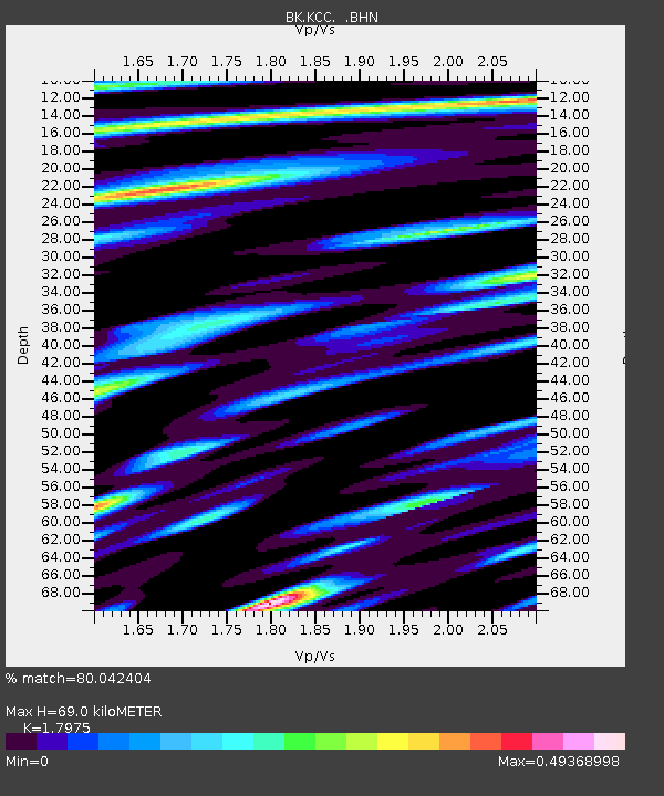
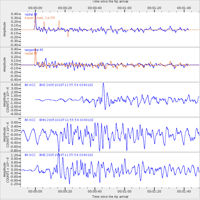
KCC Kaiser Creek, CA - Earthquake Result Viewer

Earthquake location: Near East Coast Of Honshu, Japan
Earthquake latitude/longitude: 36.4/140.8
Earthquake time(UTC): 2005/10/19 (292) 11:44:42 GMT
Earthquake Depth: 32 km
Earthquake Magnitude: 6.2 MB, 6.5 MS, 6.4 MW, 6.3 MW
Earthquake Catalog/Contributor: WHDF/NEIC
Network: BK Berkeley Digital Seismograph Network
Station: KCC Kaiser Creek, CA
Lat/Lon: 37.32 N/119.32 W
Elevation: 888 m
Distance: 75.7 deg
Az: 54.147 deg
Baz: 304.891 deg
Ray Param: 0.051439762
Estimated Moho Depth: 69.0 km
Estimated Crust Vp/Vs: 1.80
Assumed Crust Vp: 6.291 km/s
Estimated Crust Vs: 3.5 km/s
Estimated Crust Poisson's Ratio: 0.28
Radial Match: 80.042404 %
Radial Bump: 400
Transverse Match: 83.11781 %
Transverse Bump: 400
SOD ConfigId: 2564
Insert Time: 2010-03-05 19:30:55.294 +0000
GWidth: 2.5
Max Bumps: 400
Tol: 0.001

Signal To Noise

ChannelStoNSTALTA
BK:KCC: :BHN:20051019T11:55:54.034019Z2.15948532.4908445E-71.15344356E-7
BK:KCC: :BHE:20051019T11:55:54.034019Z1.55552951.968419E-71.2654334E-7
BK:KCC: :BHZ:20051019T11:55:54.034019Z2.37432584.689244E-71.9749791E-7
Arrivals
Ps9.0 SECOND
PpPs30 SECOND
PsPs/PpSs39 SECOND