You are here: Home > Network List > CB - China National Seismic Network Stations List
> Station GYA Guiyang,Yunnan Province > Earthquake Result Viewer
GYA Guiyang,Yunnan Province - Earthquake Result Viewer
| Earthquake location: |
Southwest Of Sumatra, Indonesia |
| Earthquake latitude/longitude: |
-8.1/104.8 |
| Earthquake time(UTC): |
2016/11/07 (312) 21:31:24 GMT |
| Earthquake Depth: |
10 km |
| Earthquake Magnitude: |
5.6 MWB |
| Earthquake Catalog/Contributor: |
NEIC PDE/NEIC COMCAT |
|
| Network: |
CB China National Seismic Network |
| Station: |
GYA Guiyang,Yunnan Province |
| Lat/Lon: |
26.46 N/106.66 E |
| Elevation: |
1162 m |
|
| Distance: |
34.4 deg |
| Az: |
2.915 deg |
| Baz: |
183.219 deg |
| Ray Param: |
0.07773744 |
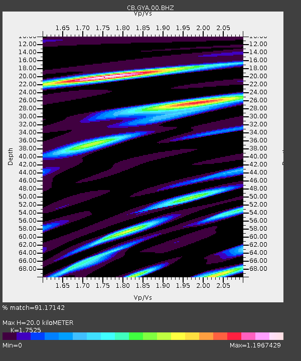
| Estimated Moho Depth: |
20.0 km |
| Estimated Crust Vp/Vs: |
1.75 |
| Assumed Crust Vp: |
6.113 km/s |
| Estimated Crust Vs: |
3.488 km/s |
| Estimated Crust Poisson's Ratio: |
0.26 |
|
| Radial Match: |
91.17142 % |
| Radial Bump: |
360 |
| Transverse Match: |
62.60607 % |
| Transverse Bump: |
400 |
| SOD ConfigId: |
11737051 |
| Insert Time: |
2019-04-26 00:24:52.201 +0000 |
| GWidth: |
2.5 |
| Max Bumps: |
400 |
| Tol: |
0.001 |
|

Signal To Noise
| Channel | StoN | STA | LTA |
| CB:GYA:00:BHZ:20161107T21:37:42.159994Z | 19.541588 | 3.0150009E-6 | 1.5428638E-7 |
| CB:GYA:00:BHN:20161107T21:37:42.159994Z | 14.121155 | 1.4767778E-6 | 1.0457911E-7 |
| CB:GYA:00:BHE:20161107T21:37:42.159994Z | 2.7600198 | 4.3906502E-7 | 1.5908039E-7 |
| Arrivals |
| Ps | 2.6 SECOND |
| PpPs | 8.4 SECOND |
| PsPs/PpSs | 11 SECOND |


