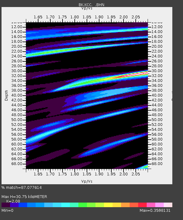
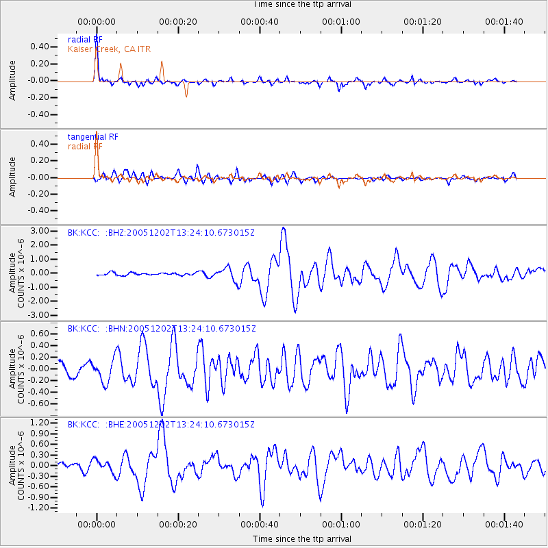
KCC Kaiser Creek, CA - Earthquake Result Viewer

Earthquake location: Near East Coast Of Honshu, Japan
Earthquake latitude/longitude: 38.1/142.1
Earthquake time(UTC): 2005/12/02 (336) 13:13:09 GMT
Earthquake Depth: 29 km
Earthquake Magnitude: 6.1 MB, 6.3 MS, 6.5 MW, 6.4 MW
Earthquake Catalog/Contributor: WHDF/NEIC
Network: BK Berkeley Digital Seismograph Network
Station: KCC Kaiser Creek, CA
Lat/Lon: 37.32 N/119.32 W
Elevation: 888 m
Distance: 73.9 deg
Az: 55.132 deg
Baz: 305.697 deg
Ray Param: 0.052653875
Estimated Moho Depth: 30.75 km
Estimated Crust Vp/Vs: 2.08
Assumed Crust Vp: 6.291 km/s
Estimated Crust Vs: 3.025 km/s
Estimated Crust Poisson's Ratio: 0.35
Radial Match: 87.077614 %
Radial Bump: 295
Transverse Match: 77.13929 %
Transverse Bump: 400
SOD ConfigId: 2422
Insert Time: 2010-03-05 19:31:04.030 +0000
GWidth: 2.5
Max Bumps: 400
Tol: 0.001

Signal To Noise

ChannelStoNSTALTA
BK:KCC: :BHN:20051202T13:24:10.673015Z2.1467221.9946165E-79.291452E-8
BK:KCC: :BHE:20051202T13:24:10.673015Z1.42133821.803328E-71.2687536E-7
BK:KCC: :BHZ:20051202T13:24:10.673015Z5.5024674.8467865E-78.808388E-8
Arrivals
Ps5.4 SECOND
PpPs15 SECOND
PsPs/PpSs20 SECOND