You are here: Home > Network List > BK - Berkeley Digital Seismograph Network Stations List
> Station KCC Kaiser Creek, CA > Earthquake Result Viewer
KCC Kaiser Creek, CA - Earthquake Result Viewer
| Earthquake location: |
Mariana Islands |
| Earthquake latitude/longitude: |
20.1/145.8 |
| Earthquake time(UTC): |
2005/08/13 (225) 07:36:52 GMT |
| Earthquake Depth: |
49 km |
| Earthquake Magnitude: |
5.8 MB, 5.6 MS, 6.0 MW, 6.0 MW |
| Earthquake Catalog/Contributor: |
WHDF/NEIC |
|
| Network: |
BK Berkeley Digital Seismograph Network |
| Station: |
KCC Kaiser Creek, CA |
| Lat/Lon: |
37.32 N/119.32 W |
| Elevation: |
888 m |
|
| Distance: |
81.8 deg |
| Az: |
53.372 deg |
| Baz: |
288.928 deg |
| Ray Param: |
0.047257002 |
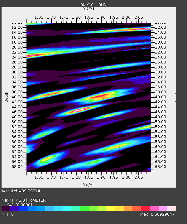
| Estimated Moho Depth: |
45.0 km |
| Estimated Crust Vp/Vs: |
1.81 |
| Assumed Crust Vp: |
6.291 km/s |
| Estimated Crust Vs: |
3.476 km/s |
| Estimated Crust Poisson's Ratio: |
0.28 |
|
| Radial Match: |
89.89014 % |
| Radial Bump: |
400 |
| Transverse Match: |
77.3996 % |
| Transverse Bump: |
400 |
| SOD ConfigId: |
2422 |
| Insert Time: |
2010-03-05 19:31:06.062 +0000 |
| GWidth: |
2.5 |
| Max Bumps: |
400 |
| Tol: |
0.001 |
|
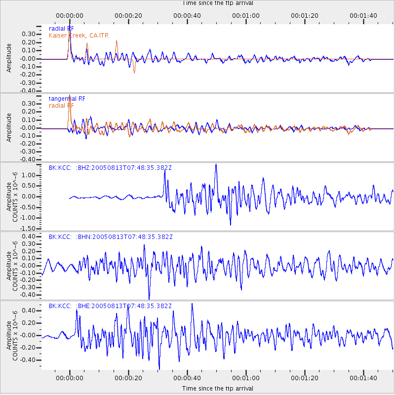
Signal To Noise
| Channel | StoN | STA | LTA |
| BK:KCC: :BHN:20050813T07:48:35.382Z | 1.1623738 | 4.929835E-8 | 4.2411788E-8 |
| BK:KCC: :BHE:20050813T07:48:35.382Z | 5.9985757 | 1.5174767E-7 | 2.5297284E-8 |
| BK:KCC: :BHZ:20050813T07:48:35.382Z | 9.022355 | 4.1804188E-7 | 4.6334005E-8 |
| Arrivals |
| Ps | 5.9 SECOND |
| PpPs | 20 SECOND |
| PsPs/PpSs | 26 SECOND |


