You are here: Home > Network List > BK - Berkeley Digital Seismograph Network Stations List
> Station KCC Kaiser Creek, CA > Earthquake Result Viewer
KCC Kaiser Creek, CA - Earthquake Result Viewer
| Earthquake location: |
Southeast Of Honshu, Japan |
| Earthquake latitude/longitude: |
33.4/140.8 |
| Earthquake time(UTC): |
2005/07/09 (190) 23:37:11 GMT |
| Earthquake Depth: |
55 km |
| Earthquake Magnitude: |
5.8 MB, 5.8 MW, 5.8 MW |
| Earthquake Catalog/Contributor: |
WHDF/NEIC |
|
| Network: |
BK Berkeley Digital Seismograph Network |
| Station: |
KCC Kaiser Creek, CA |
| Lat/Lon: |
37.32 N/119.32 W |
| Elevation: |
888 m |
|
| Distance: |
77.5 deg |
| Az: |
53.568 deg |
| Baz: |
302.427 deg |
| Ray Param: |
0.05019106 |
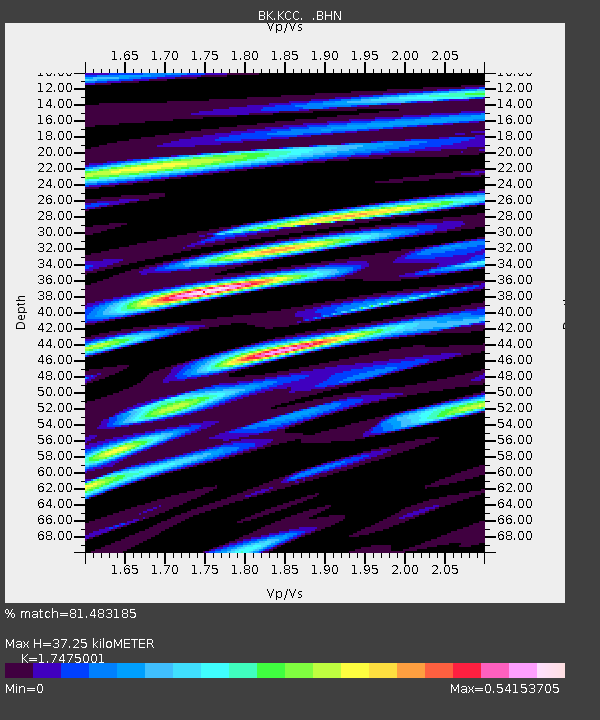
| Estimated Moho Depth: |
37.25 km |
| Estimated Crust Vp/Vs: |
1.75 |
| Assumed Crust Vp: |
6.291 km/s |
| Estimated Crust Vs: |
3.6 km/s |
| Estimated Crust Poisson's Ratio: |
0.26 |
|
| Radial Match: |
81.483185 % |
| Radial Bump: |
400 |
| Transverse Match: |
62.570206 % |
| Transverse Bump: |
400 |
| SOD ConfigId: |
2422 |
| Insert Time: |
2010-03-05 19:31:07.576 +0000 |
| GWidth: |
2.5 |
| Max Bumps: |
400 |
| Tol: |
0.001 |
|
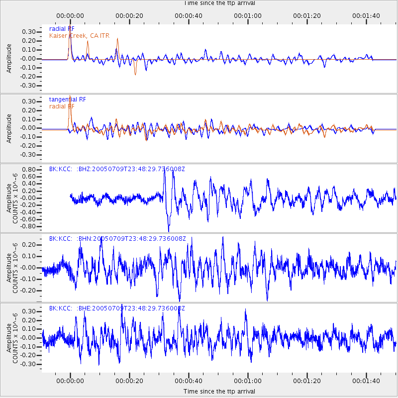
Signal To Noise
| Channel | StoN | STA | LTA |
| BK:KCC: :BHN:20050709T23:48:29.736008Z | 1.6539742 | 9.642806E-8 | 5.8300827E-8 |
| BK:KCC: :BHE:20050709T23:48:29.736008Z | 2.150553 | 1.2662149E-7 | 5.8878566E-8 |
| BK:KCC: :BHZ:20050709T23:48:29.736008Z | 5.7809367 | 4.4254108E-7 | 7.65518E-8 |
| Arrivals |
| Ps | 4.6 SECOND |
| PpPs | 16 SECOND |
| PsPs/PpSs | 20 SECOND |


