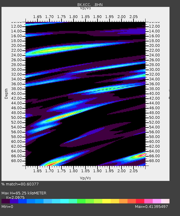
KCC Kaiser Creek, CA - Earthquake Result Viewer
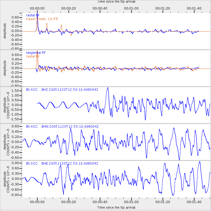
Earthquake location: Unimak Island Region, Alaska
Earthquake latitude/longitude: 53.8/-164.1
Earthquake time(UTC): 2005/11/20 (324) 12:53:02 GMT
Earthquake Depth: 30 km
Earthquake Magnitude: 5.7 MB, 5.8 MS, 6.2 MW, 6.0 MW
Earthquake Catalog/Contributor: WHDF/NEIC
Network: BK Berkeley Digital Seismograph Network
Station: KCC Kaiser Creek, CA
Lat/Lon: 37.32 N/119.32 W
Elevation: 888 m
Distance: 34.7 deg
Az: 99.909 deg
Baz: 312.924 deg
Ray Param: 0.07753044
Estimated Moho Depth: 65.25 km
Estimated Crust Vp/Vs: 2.10
Assumed Crust Vp: 6.291 km/s
Estimated Crust Vs: 2.999 km/s
Estimated Crust Poisson's Ratio: 0.35
Radial Match: 80.60377 %
Radial Bump: 293
Transverse Match: 68.471405 %
Transverse Bump: 400
SOD ConfigId: 2448
Insert Time: 2010-03-05 19:31:09.206 +0000
GWidth: 2.5
Max Bumps: 400
Tol: 0.001

Signal To Noise

ChannelStoNSTALTA
BK:KCC: :BHN:20051120T12:59:19.998004Z0.425017634.4889138E-81.0561712E-7
BK:KCC: :BHE:20051120T12:59:19.998004Z3.07353041.9951378E-76.491356E-8
BK:KCC: :BHZ:20051120T12:59:19.998004Z1.27718542.8814742E-72.2561126E-7
Arrivals
Ps12 SECOND
PpPs30 SECOND
PsPs/PpSs42 SECOND