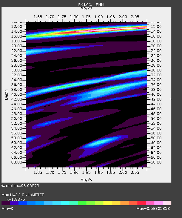
KCC Kaiser Creek, CA - Earthquake Result Viewer
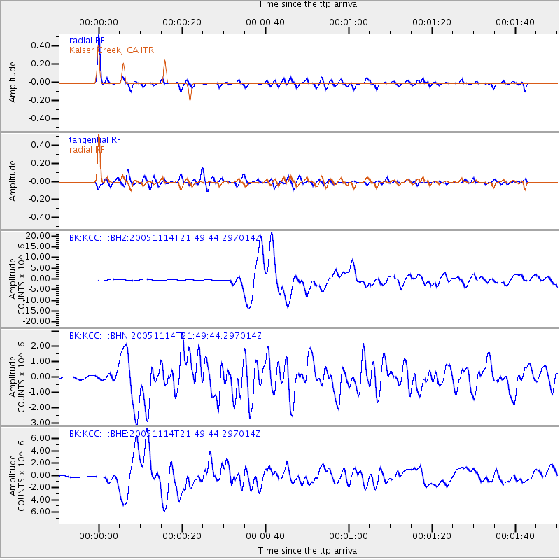
Earthquake location: Off East Coast Of Honshu, Japan
Earthquake latitude/longitude: 38.1/144.9
Earthquake time(UTC): 2005/11/14 (318) 21:38:51 GMT
Earthquake Depth: 11 km
Earthquake Magnitude: 6.7 MB, 6.8 MS, 7.0 MW, 6.9 MW
Earthquake Catalog/Contributor: WHDF/NEIC
Network: BK Berkeley Digital Seismograph Network
Station: KCC Kaiser Creek, CA
Lat/Lon: 37.32 N/119.32 W
Elevation: 888 m
Distance: 72.1 deg
Az: 56.465 deg
Baz: 304.426 deg
Ray Param: 0.053895473
Estimated Moho Depth: 13.0 km
Estimated Crust Vp/Vs: 1.94
Assumed Crust Vp: 6.291 km/s
Estimated Crust Vs: 3.247 km/s
Estimated Crust Poisson's Ratio: 0.32
Radial Match: 95.93878 %
Radial Bump: 340
Transverse Match: 90.77095 %
Transverse Bump: 400
SOD ConfigId: 2448
Insert Time: 2010-03-05 19:31:11.449 +0000
GWidth: 2.5
Max Bumps: 400
Tol: 0.001

Signal To Noise

ChannelStoNSTALTA
BK:KCC: :BHN:20051114T21:49:44.297014Z3.0906842.534955E-78.201922E-8
BK:KCC: :BHE:20051114T21:49:44.297014Z3.56779555.8835667E-71.6490763E-7
BK:KCC: :BHZ:20051114T21:49:44.297014Z7.6474751.591781E-62.0814466E-7
Arrivals
Ps2.0 SECOND
PpPs5.9 SECOND
PsPs/PpSs7.9 SECOND