You are here: Home > Network List > BK - Berkeley Digital Seismograph Network Stations List
> Station KCC Kaiser Creek, CA > Earthquake Result Viewer
KCC Kaiser Creek, CA - Earthquake Result Viewer
| Earthquake location: |
Vanuatu Islands Region |
| Earthquake latitude/longitude: |
-21.1/173.9 |
| Earthquake time(UTC): |
2005/08/09 (221) 14:12:21 GMT |
| Earthquake Depth: |
35 km |
| Earthquake Magnitude: |
5.3 MB, 5.9 MS, 6.1 MW, 6.0 MW |
| Earthquake Catalog/Contributor: |
WHDF/NEIC |
|
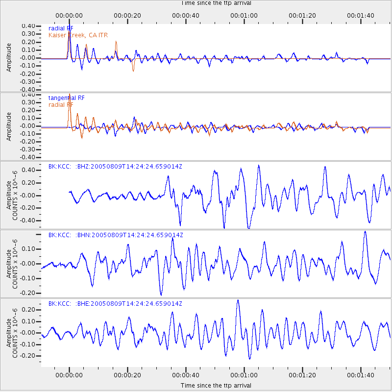
| Network: |
BK Berkeley Digital Seismograph Network |
| Station: |
KCC Kaiser Creek, CA |
| Lat/Lon: |
37.32 N/119.32 W |
| Elevation: |
888 m |
|
| Distance: |
85.6 deg |
| Az: |
47.303 deg |
| Baz: |
239.416 deg |
| Ray Param: |
0.044617422 |
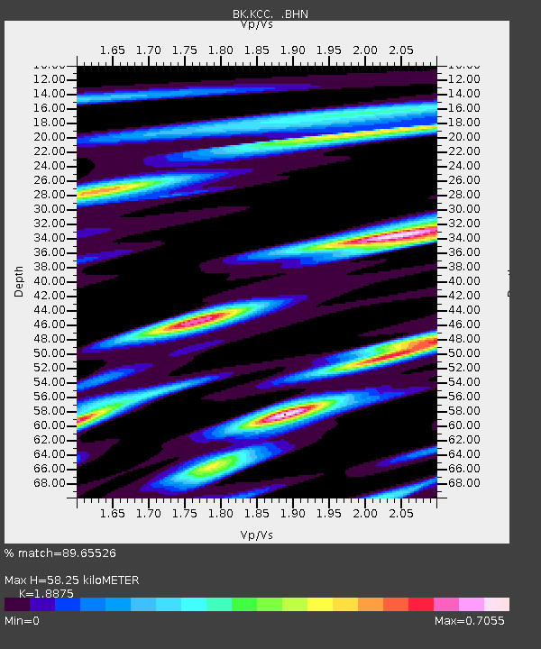
| Estimated Moho Depth: |
58.25 km |
| Estimated Crust Vp/Vs: |
1.89 |
| Assumed Crust Vp: |
6.291 km/s |
| Estimated Crust Vs: |
3.333 km/s |
| Estimated Crust Poisson's Ratio: |
0.30 |
|
| Radial Match: |
89.65526 % |
| Radial Bump: |
375 |
| Transverse Match: |
56.583176 % |
| Transverse Bump: |
400 |
| SOD ConfigId: |
2475 |
| Insert Time: |
2010-03-05 19:31:19.668 +0000 |
| GWidth: |
2.5 |
| Max Bumps: |
400 |
| Tol: |
0.001 |
|
Signal To Noise
| Channel | StoN | STA | LTA |
| BK:KCC: :BHN:20050809T14:24:24.659014Z | 1.1755573 | 3.2562774E-8 | 2.7699862E-8 |
| BK:KCC: :BHE:20050809T14:24:24.659014Z | 1.4989706 | 3.9671463E-8 | 2.6465802E-8 |
| BK:KCC: :BHZ:20050809T14:24:24.659014Z | 2.5884104 | 1.2784143E-7 | 4.938994E-8 |
| Arrivals |
| Ps | 8.4 SECOND |
| PpPs | 26 SECOND |
| PsPs/PpSs | 35 SECOND |


