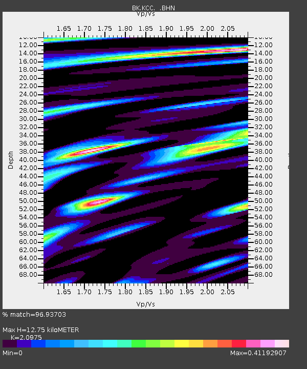
KCC Kaiser Creek, CA - Earthquake Result Viewer
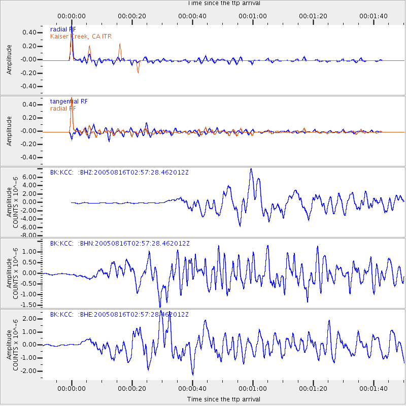
Earthquake location: Near East Coast Of Honshu, Japan
Earthquake latitude/longitude: 38.3/142.0
Earthquake time(UTC): 2005/08/16 (228) 02:46:28 GMT
Earthquake Depth: 36 km
Earthquake Magnitude: 6.5 MB, 6.8 MS, 7.2 MW, 7.1 MW
Earthquake Catalog/Contributor: WHDF/NEIC
Network: BK Berkeley Digital Seismograph Network
Station: KCC Kaiser Creek, CA
Lat/Lon: 37.32 N/119.32 W
Elevation: 888 m
Distance: 73.8 deg
Az: 55.136 deg
Baz: 305.896 deg
Ray Param: 0.052673314
Estimated Moho Depth: 12.75 km
Estimated Crust Vp/Vs: 2.10
Assumed Crust Vp: 6.291 km/s
Estimated Crust Vs: 2.999 km/s
Estimated Crust Poisson's Ratio: 0.35
Radial Match: 96.93703 %
Radial Bump: 362
Transverse Match: 90.05908 %
Transverse Bump: 400
SOD ConfigId: 2475
Insert Time: 2010-03-05 19:31:22.749 +0000
GWidth: 2.5
Max Bumps: 400
Tol: 0.001

Signal To Noise

ChannelStoNSTALTA
BK:KCC: :BHN:20050816T02:57:28.462012Z1.8109578.61977E-84.7597872E-8
BK:KCC: :BHE:20050816T02:57:28.462012Z4.83913141.954667E-74.039293E-8
BK:KCC: :BHZ:20050816T02:57:28.462012Z6.49248935.3639604E-78.261793E-8
Arrivals
Ps2.3 SECOND
PpPs6.1 SECOND
PsPs/PpSs8.4 SECOND