You are here: Home > Network List > BK - Berkeley Digital Seismograph Network Stations List
> Station KCC Kaiser Creek, CA > Earthquake Result Viewer
KCC Kaiser Creek, CA - Earthquake Result Viewer
| Earthquake location: |
New Ireland Region, P.N.G. |
| Earthquake latitude/longitude: |
-4.5/153.5 |
| Earthquake time(UTC): |
2005/09/09 (252) 07:26:43 GMT |
| Earthquake Depth: |
90 km |
| Earthquake Magnitude: |
6.3 MB, 7.7 MW, 7.5 MW |
| Earthquake Catalog/Contributor: |
WHDF/NEIC |
|
| Network: |
BK Berkeley Digital Seismograph Network |
| Station: |
KCC Kaiser Creek, CA |
| Lat/Lon: |
37.32 N/119.32 W |
| Elevation: |
888 m |
|
| Distance: |
90.5 deg |
| Az: |
52.775 deg |
| Baz: |
264.722 deg |
| Ray Param: |
0.04165175 |
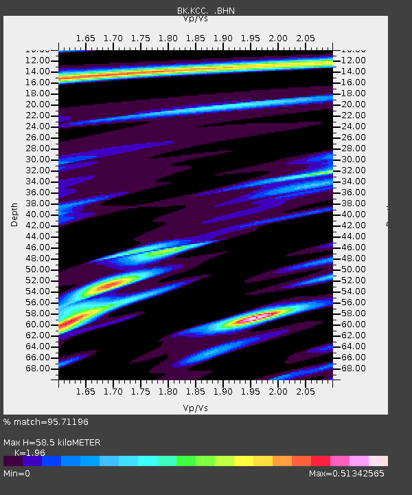
| Estimated Moho Depth: |
58.5 km |
| Estimated Crust Vp/Vs: |
1.96 |
| Assumed Crust Vp: |
6.291 km/s |
| Estimated Crust Vs: |
3.21 km/s |
| Estimated Crust Poisson's Ratio: |
0.32 |
|
| Radial Match: |
95.71196 % |
| Radial Bump: |
329 |
| Transverse Match: |
90.41643 % |
| Transverse Bump: |
400 |
| SOD ConfigId: |
2475 |
| Insert Time: |
2010-03-05 19:31:27.523 +0000 |
| GWidth: |
2.5 |
| Max Bumps: |
400 |
| Tol: |
0.001 |
|
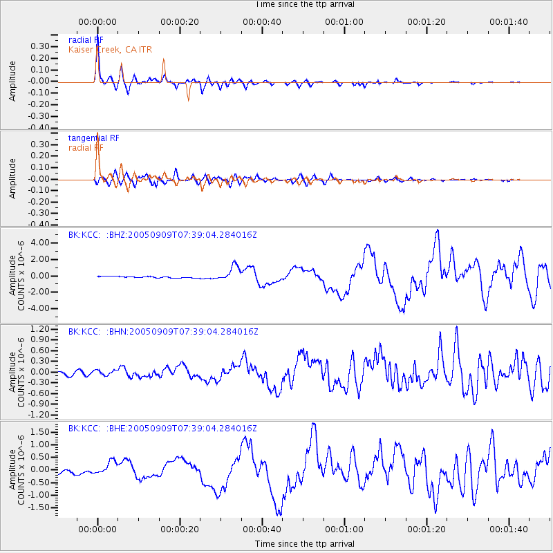
Signal To Noise
| Channel | StoN | STA | LTA |
| BK:KCC: :BHN:20050909T07:39:04.284016Z | 1.6021242 | 7.265182E-8 | 4.5347186E-8 |
| BK:KCC: :BHE:20050909T07:39:04.284016Z | 5.340431 | 2.77312E-7 | 5.1926893E-8 |
| BK:KCC: :BHZ:20050909T07:39:04.284016Z | 11.388619 | 9.689475E-7 | 8.508033E-8 |
| Arrivals |
| Ps | 9.1 SECOND |
| PpPs | 27 SECOND |
| PsPs/PpSs | 36 SECOND |


