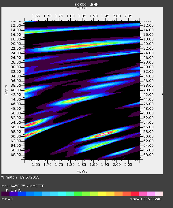
KCC Kaiser Creek, CA - Earthquake Result Viewer
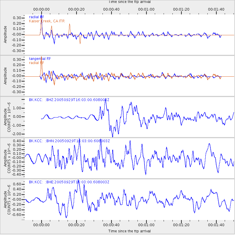
Earthquake location: New Britain Region, P.N.G.
Earthquake latitude/longitude: -5.4/151.8
Earthquake time(UTC): 2005/09/29 (272) 15:50:24 GMT
Earthquake Depth: 25 km
Earthquake Magnitude: 5.9 MB, 6.6 MS, 6.7 MW, 6.5 MW
Earthquake Catalog/Contributor: WHDF/NEIC
Network: BK Berkeley Digital Seismograph Network
Station: KCC Kaiser Creek, CA
Lat/Lon: 37.32 N/119.32 W
Elevation: 888 m
Distance: 92.3 deg
Az: 52.909 deg
Baz: 264.994 deg
Ray Param: 0.041468162
Estimated Moho Depth: 58.75 km
Estimated Crust Vp/Vs: 1.95
Assumed Crust Vp: 6.291 km/s
Estimated Crust Vs: 3.235 km/s
Estimated Crust Poisson's Ratio: 0.32
Radial Match: 89.572655 %
Radial Bump: 400
Transverse Match: 73.078094 %
Transverse Bump: 400
SOD ConfigId: 2475
Insert Time: 2010-03-05 19:31:30.901 +0000
GWidth: 2.5
Max Bumps: 400
Tol: 0.001

Signal To Noise

ChannelStoNSTALTA
BK:KCC: :BHN:20050929T16:03:00.608003Z0.77053716.569867E-88.526348E-8
BK:KCC: :BHE:20050929T16:03:00.608003Z2.8967011.6117568E-75.5641117E-8
BK:KCC: :BHZ:20050929T16:03:00.608003Z3.9839674.379015E-71.0991594E-7
Arrivals
Ps9.0 SECOND
PpPs27 SECOND
PsPs/PpSs36 SECOND