You are here: Home > Network List > IW - Intermountain West Stations List
> Station MOOW Moose Ponds, Wyoming, USA > Earthquake Result Viewer
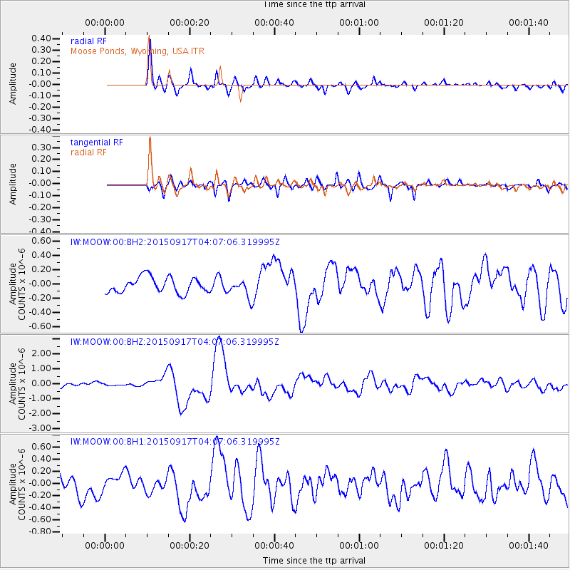
MOOW Moose Ponds, Wyoming, USA - Earthquake Result Viewer
*The percent match for this event was below the threshold and hence no stack was calculated.
| Earthquake location: |
Near Coast Of Central Chile |
| Earthquake latitude/longitude: |
-31.0/-71.4 |
| Earthquake time(UTC): |
2015/09/17 (260) 03:55:07 GMT |
| Earthquake Depth: |
35 km |
| Earthquake Magnitude: |
6.2 MO |
| Earthquake Catalog/Contributor: |
NEIC PDE/NEIC ALERT |
|
| Network: |
IW Intermountain West |
| Station: |
MOOW Moose Ponds, Wyoming, USA |
| Lat/Lon: |
43.75 N/110.74 W |
| Elevation: |
2128 m |
|
| Distance: |
82.6 deg |
| Az: |
332.376 deg |
| Baz: |
146.664 deg |
| Ray Param: |
$rayparam |
*The percent match for this event was below the threshold and hence was not used in the summary stack. |
|
| Radial Match: |
84.56746 % |
| Radial Bump: |
400 |
| Transverse Match: |
72.525856 % |
| Transverse Bump: |
400 |
| SOD ConfigId: |
1259291 |
| Insert Time: |
2015-10-28 23:22:55.787 +0000 |
| GWidth: |
2.5 |
| Max Bumps: |
400 |
| Tol: |
0.001 |
|
Signal To Noise
| Channel | StoN | STA | LTA |
| IW:MOOW:00:BHZ:20150917T04:07:06.319995Z | 0.32651582 | 5.3661513E-8 | 1.6434582E-7 |
| IW:MOOW:00:BH1:20150917T04:07:06.319995Z | 0.870921 | 1.3845963E-7 | 1.589807E-7 |
| IW:MOOW:00:BH2:20150917T04:07:06.319995Z | 0.93210244 | 9.909262E-8 | 1.06310864E-7 |
| Arrivals |
| Ps | |
| PpPs | |
| PsPs/PpSs | |


