You are here: Home > Network List > BK - Berkeley Digital Seismograph Network Stations List
> Station KCC Kaiser Creek, CA > Earthquake Result Viewer
KCC Kaiser Creek, CA - Earthquake Result Viewer
| Earthquake location: |
Vanuatu Islands |
| Earthquake latitude/longitude: |
-19.2/168.7 |
| Earthquake time(UTC): |
2007/08/05 (217) 09:28:40 GMT |
| Earthquake Depth: |
45 km |
| Earthquake Magnitude: |
5.6 MB, 5.5 MS, 6.0 MW, 5.9 MW |
| Earthquake Catalog/Contributor: |
WHDF/NEIC |
|
| Network: |
BK Berkeley Digital Seismograph Network |
| Station: |
KCC Kaiser Creek, CA |
| Lat/Lon: |
37.32 N/119.32 W |
| Elevation: |
888 m |
|
| Distance: |
87.9 deg |
| Az: |
49.334 deg |
| Baz: |
244.089 deg |
| Ray Param: |
0.04290478 |
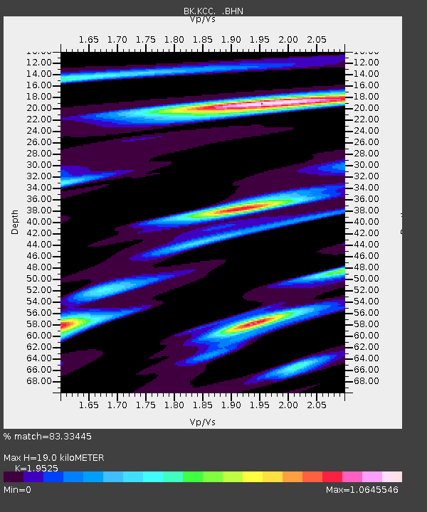
| Estimated Moho Depth: |
19.0 km |
| Estimated Crust Vp/Vs: |
1.95 |
| Assumed Crust Vp: |
6.291 km/s |
| Estimated Crust Vs: |
3.222 km/s |
| Estimated Crust Poisson's Ratio: |
0.32 |
|
| Radial Match: |
83.33445 % |
| Radial Bump: |
400 |
| Transverse Match: |
61.869568 % |
| Transverse Bump: |
400 |
| SOD ConfigId: |
2564 |
| Insert Time: |
2010-03-05 19:32:00.384 +0000 |
| GWidth: |
2.5 |
| Max Bumps: |
400 |
| Tol: |
0.001 |
|
Signal To Noise
| Channel | StoN | STA | LTA |
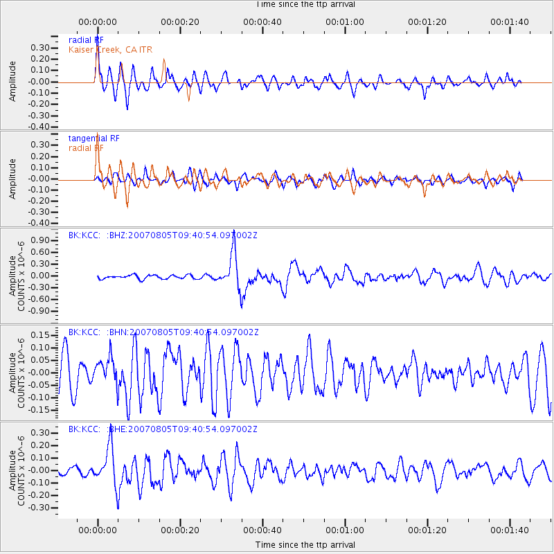
| BK:KCC: :BHN:20070805T09:40:54.097002Z | 0.89508295 | 5.2610602E-8 | 5.877735E-8 |
| BK:KCC: :BHE:20070805T09:40:54.097002Z | 5.3103447 | 1.6095768E-7 | 3.0310215E-8 |
| BK:KCC: :BHZ:20070805T09:40:54.097002Z | 9.658158 | 4.6156669E-7 | 4.7790344E-8 |
| Arrivals |
| Ps | 2.9 SECOND |
| PpPs | 8.7 SECOND |
| PsPs/PpSs | 12 SECOND |


