You are here: Home > Network List > BK - Berkeley Digital Seismograph Network Stations List
> Station KCC Kaiser Creek, CA > Earthquake Result Viewer
KCC Kaiser Creek, CA - Earthquake Result Viewer
| Earthquake location: |
Jujuy Province, Argentina |
| Earthquake latitude/longitude: |
-22.2/-65.8 |
| Earthquake time(UTC): |
2007/07/21 (202) 15:34:52 GMT |
| Earthquake Depth: |
290 km |
| Earthquake Magnitude: |
5.8 MB, 6.4 MW, 6.3 MW |
| Earthquake Catalog/Contributor: |
WHDF/NEIC |
|
| Network: |
BK Berkeley Digital Seismograph Network |
| Station: |
KCC Kaiser Creek, CA |
| Lat/Lon: |
37.32 N/119.32 W |
| Elevation: |
888 m |
|
| Distance: |
77.7 deg |
| Az: |
318.989 deg |
| Baz: |
130.26 deg |
| Ray Param: |
0.049354967 |
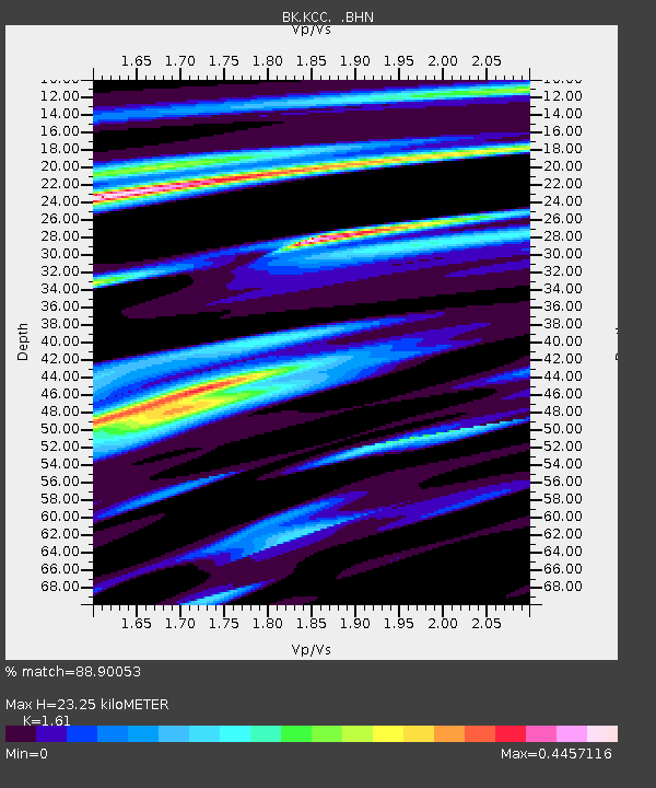
| Estimated Moho Depth: |
23.25 km |
| Estimated Crust Vp/Vs: |
1.61 |
| Assumed Crust Vp: |
6.291 km/s |
| Estimated Crust Vs: |
3.908 km/s |
| Estimated Crust Poisson's Ratio: |
0.19 |
|
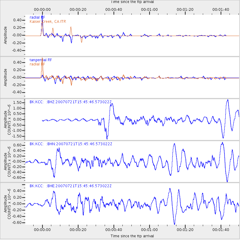
| Radial Match: |
88.90053 % |
| Radial Bump: |
306 |
| Transverse Match: |
71.248245 % |
| Transverse Bump: |
400 |
| SOD ConfigId: |
2564 |
| Insert Time: |
2010-03-05 19:32:06.559 +0000 |
| GWidth: |
2.5 |
| Max Bumps: |
400 |
| Tol: |
0.001 |
|
Signal To Noise
| Channel | StoN | STA | LTA |
| BK:KCC: :BHN:20070721T15:45:46.573022Z | 1.4269702 | 5.718381E-8 | 4.0073584E-8 |
| BK:KCC: :BHE:20070721T15:45:46.573022Z | 1.8126594 | 7.4620424E-8 | 4.116627E-8 |
| BK:KCC: :BHZ:20070721T15:45:46.573022Z | 3.4048274 | 2.0083314E-7 | 5.8984828E-8 |
| Arrivals |
| Ps | 2.3 SECOND |
| PpPs | 9.4 SECOND |
| PsPs/PpSs | 12 SECOND |


