You are here: Home > Network List > BK - Berkeley Digital Seismograph Network Stations List
> Station KCC Kaiser Creek, CA > Earthquake Result Viewer
KCC Kaiser Creek, CA - Earthquake Result Viewer
| Earthquake location: |
South Of Fiji Islands |
| Earthquake latitude/longitude: |
-26.3/-177.7 |
| Earthquake time(UTC): |
2007/07/18 (199) 00:07:35 GMT |
| Earthquake Depth: |
10 km |
| Earthquake Magnitude: |
5.8 MB, 5.9 MS, 6.1 MW, 6.0 MW |
| Earthquake Catalog/Contributor: |
WHDF/NEIC |
|
| Network: |
BK Berkeley Digital Seismograph Network |
| Station: |
KCC Kaiser Creek, CA |
| Lat/Lon: |
37.32 N/119.32 W |
| Elevation: |
888 m |
|
| Distance: |
83.8 deg |
| Az: |
43.092 deg |
| Baz: |
230.293 deg |
| Ray Param: |
0.045961753 |
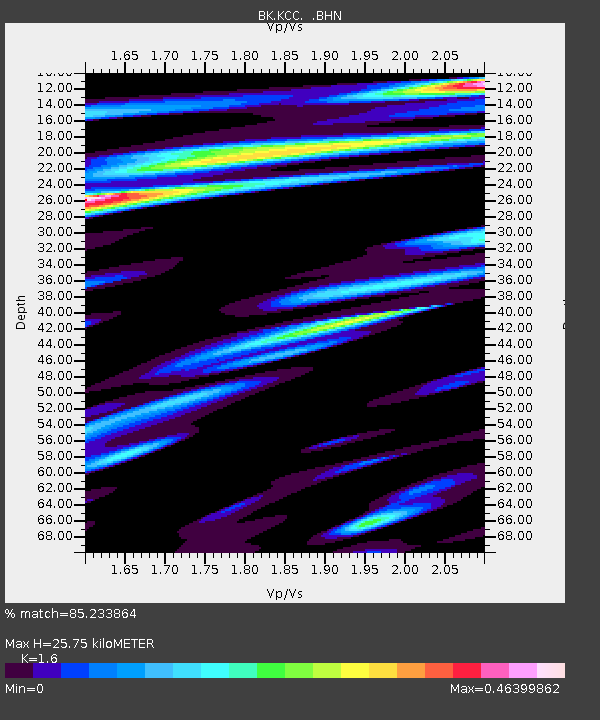
| Estimated Moho Depth: |
25.75 km |
| Estimated Crust Vp/Vs: |
1.60 |
| Assumed Crust Vp: |
6.291 km/s |
| Estimated Crust Vs: |
3.932 km/s |
| Estimated Crust Poisson's Ratio: |
0.18 |
|
| Radial Match: |
85.233864 % |
| Radial Bump: |
400 |
| Transverse Match: |
75.113205 % |
| Transverse Bump: |
400 |
| SOD ConfigId: |
2564 |
| Insert Time: |
2010-03-05 19:32:08.521 +0000 |
| GWidth: |
2.5 |
| Max Bumps: |
400 |
| Tol: |
0.001 |
|

Signal To Noise
| Channel | StoN | STA | LTA |
| BK:KCC: :BHN:20070718T00:19:33.173013Z | 1.409191 | 5.6225748E-8 | 3.989931E-8 |
| BK:KCC: :BHE:20070718T00:19:33.173013Z | 2.494509 | 5.5842435E-8 | 2.2386143E-8 |
| BK:KCC: :BHZ:20070718T00:19:33.173013Z | 1.2020663 | 6.8300025E-8 | 5.6818852E-8 |
| Arrivals |
| Ps | 2.5 SECOND |
| PpPs | 10 SECOND |
| PsPs/PpSs | 13 SECOND |


