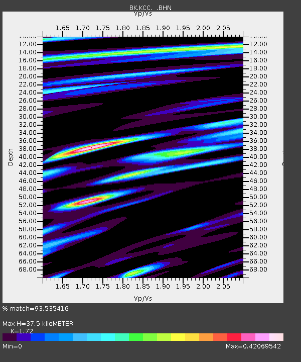
KCC Kaiser Creek, CA - Earthquake Result Viewer
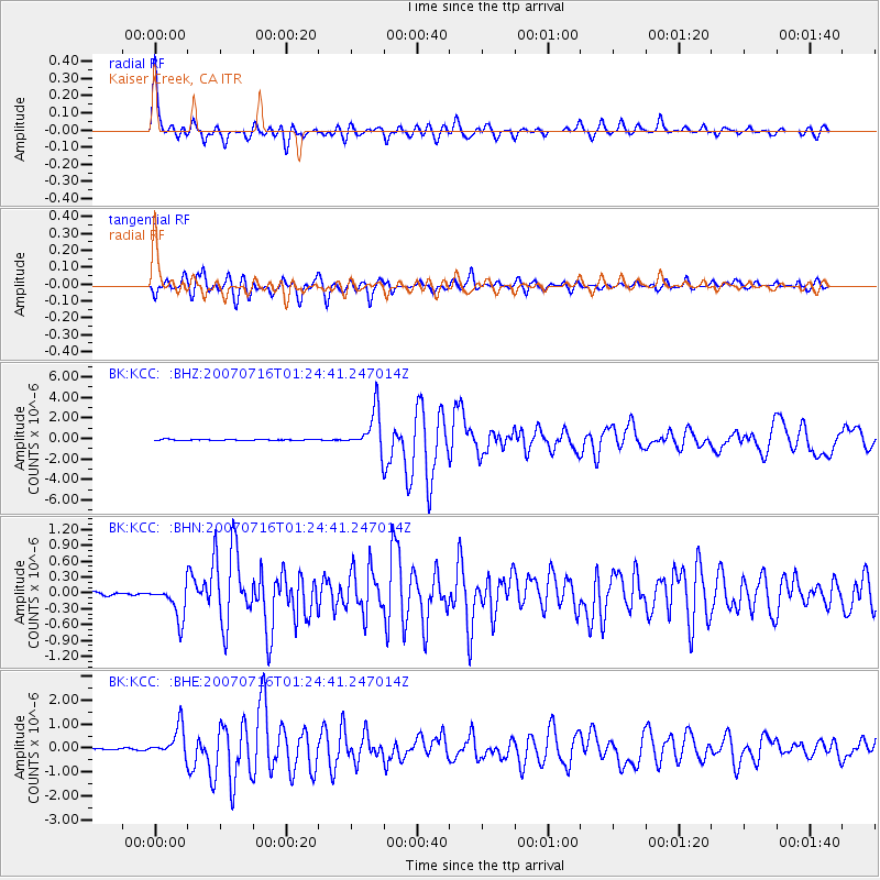
Earthquake location: Near West Coast Of Honshu, Japan
Earthquake latitude/longitude: 37.5/138.4
Earthquake time(UTC): 2007/07/16 (197) 01:13:22 GMT
Earthquake Depth: 12 km
Earthquake Magnitude: 6.5 MB, 6.4 MS, 6.6 MW, 6.5 MW
Earthquake Catalog/Contributor: WHDF/NEIC
Network: BK Berkeley Digital Seismograph Network
Station: KCC Kaiser Creek, CA
Lat/Lon: 37.32 N/119.32 W
Elevation: 888 m
Distance: 76.6 deg
Az: 53.218 deg
Baz: 306.996 deg
Ray Param: 0.05089045
Estimated Moho Depth: 37.5 km
Estimated Crust Vp/Vs: 1.72
Assumed Crust Vp: 6.291 km/s
Estimated Crust Vs: 3.658 km/s
Estimated Crust Poisson's Ratio: 0.24
Radial Match: 93.535416 %
Radial Bump: 400
Transverse Match: 93.22417 %
Transverse Bump: 400
SOD ConfigId: 2564
Insert Time: 2010-03-05 19:32:13.353 +0000
GWidth: 2.5
Max Bumps: 400
Tol: 0.001

Signal To Noise

ChannelStoNSTALTA
BK:KCC: :BHN:20070716T01:24:41.247014Z10.5851643.2319355E-73.0532693E-8
BK:KCC: :BHE:20070716T01:24:41.247014Z29.2144686.268013E-72.1455168E-8
BK:KCC: :BHZ:20070716T01:24:41.247014Z38.360741.9811953E-65.1646424E-8
Arrivals
Ps4.4 SECOND
PpPs16 SECOND
PsPs/PpSs20 SECOND