You are here: Home > Network List > US - United States National Seismic Network Stations List
> Station HAWA Hanford, Washington, USA > Earthquake Result Viewer
HAWA Hanford, Washington, USA - Earthquake Result Viewer
*The percent match for this event was below the threshold and hence no stack was calculated.
| Earthquake location: |
Near Coast Of Central Chile |
| Earthquake latitude/longitude: |
-31.0/-71.4 |
| Earthquake time(UTC): |
2015/09/17 (260) 03:55:07 GMT |
| Earthquake Depth: |
35 km |
| Earthquake Magnitude: |
6.2 MO |
| Earthquake Catalog/Contributor: |
NEIC PDE/NEIC ALERT |
|
| Network: |
US United States National Seismic Network |
| Station: |
HAWA Hanford, Washington, USA |
| Lat/Lon: |
46.39 N/119.53 W |
| Elevation: |
364 m |
|
| Distance: |
88.5 deg |
| Az: |
328.94 deg |
| Baz: |
140.188 deg |
| Ray Param: |
$rayparam |
*The percent match for this event was below the threshold and hence was not used in the summary stack. |
|
| Radial Match: |
59.26104 % |
| Radial Bump: |
400 |
| Transverse Match: |
56.97609 % |
| Transverse Bump: |
400 |
| SOD ConfigId: |
1259291 |
| Insert Time: |
2015-10-28 23:26:49.780 +0000 |
| GWidth: |
2.5 |
| Max Bumps: |
400 |
| Tol: |
0.001 |
|
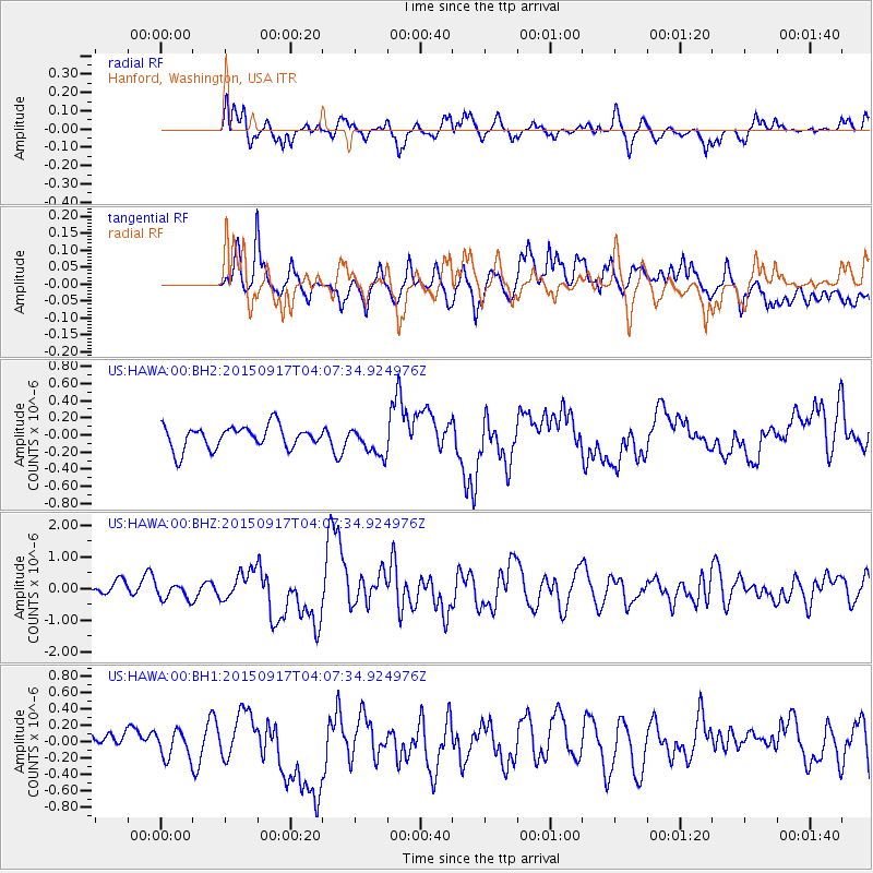
Signal To Noise
| Channel | StoN | STA | LTA |
| US:HAWA:00:BHZ:20150917T04:07:34.924976Z | 1.2101576 | 2.3820802E-7 | 1.9684049E-7 |
| US:HAWA:00:BH1:20150917T04:07:34.924976Z | 1.6522985 | 3.0891937E-7 | 1.8696342E-7 |
| US:HAWA:00:BH2:20150917T04:07:34.924976Z | 0.5871398 | 8.0118156E-8 | 1.3645499E-7 |
| Arrivals |
| Ps | |
| PpPs | |
| PsPs/PpSs | |


