You are here: Home > Network List > AZ - ANZA Regional Network Stations List
> Station SMER AZ.SMER > Earthquake Result Viewer
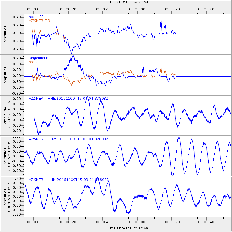
SMER AZ.SMER - Earthquake Result Viewer
*The percent match for this event was below the threshold and hence no stack was calculated.
| Earthquake location: |
Bismarck Sea |
| Earthquake latitude/longitude: |
-4.7/149.9 |
| Earthquake time(UTC): |
2016/11/09 (314) 14:50:59 GMT |
| Earthquake Depth: |
446 km |
| Earthquake Magnitude: |
5.9 MWB |
| Earthquake Catalog/Contributor: |
NEIC PDE/NEIC COMCAT |
|
| Network: |
AZ ANZA Regional Network |
| Station: |
SMER AZ.SMER |
| Lat/Lon: |
33.46 N/117.17 W |
| Elevation: |
355 m |
|
| Distance: |
95.1 deg |
| Az: |
56.943 deg |
| Baz: |
267.695 deg |
| Ray Param: |
$rayparam |
*The percent match for this event was below the threshold and hence was not used in the summary stack. |
|
| Radial Match: |
59.854866 % |
| Radial Bump: |
400 |
| Transverse Match: |
57.871544 % |
| Transverse Bump: |
400 |
| SOD ConfigId: |
11737051 |
| Insert Time: |
2019-04-26 00:39:07.349 +0000 |
| GWidth: |
2.5 |
| Max Bumps: |
400 |
| Tol: |
0.001 |
|
Signal To Noise
| Channel | StoN | STA | LTA |
| AZ:SMER: :HHZ:20161109T15:03:01.87803Z | 0.54907966 | 2.4913723E-7 | 4.5373605E-7 |
| AZ:SMER: :HHN:20161109T15:03:01.87803Z | 0.78100634 | 7.186824E-7 | 9.202004E-7 |
| AZ:SMER: :HHE:20161109T15:03:01.87803Z | 2.0751052 | 8.161402E-7 | 3.9330064E-7 |
| Arrivals |
| Ps | |
| PpPs | |
| PsPs/PpSs | |


