You are here: Home > Network List > TA - USArray Transportable Network (new EarthScope stations) Stations List
> Station D25K Kavik River, AK, USA > Earthquake Result Viewer
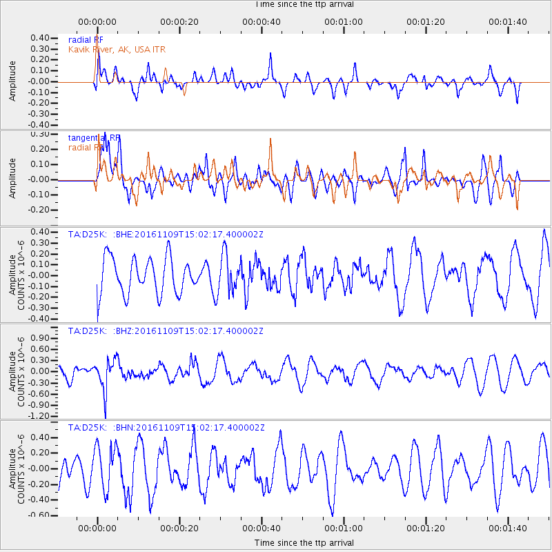
D25K Kavik River, AK, USA - Earthquake Result Viewer
*The percent match for this event was below the threshold and hence no stack was calculated.
| Earthquake location: |
Bismarck Sea |
| Earthquake latitude/longitude: |
-4.7/149.9 |
| Earthquake time(UTC): |
2016/11/09 (314) 14:50:59 GMT |
| Earthquake Depth: |
446 km |
| Earthquake Magnitude: |
5.9 MWB |
| Earthquake Catalog/Contributor: |
NEIC PDE/NEIC COMCAT |
|
| Network: |
TA USArray Transportable Network (new EarthScope stations) |
| Station: |
D25K Kavik River, AK, USA |
| Lat/Lon: |
69.32 N/146.38 W |
| Elevation: |
770 m |
|
| Distance: |
85.4 deg |
| Az: |
18.642 deg |
| Baz: |
243.755 deg |
| Ray Param: |
$rayparam |
*The percent match for this event was below the threshold and hence was not used in the summary stack. |
|
| Radial Match: |
58.060696 % |
| Radial Bump: |
400 |
| Transverse Match: |
43.106 % |
| Transverse Bump: |
400 |
| SOD ConfigId: |
11737051 |
| Insert Time: |
2019-04-26 00:42:02.264 +0000 |
| GWidth: |
2.5 |
| Max Bumps: |
400 |
| Tol: |
0.001 |
|
Signal To Noise
| Channel | StoN | STA | LTA |
| TA:D25K: :BHZ:20161109T15:02:17.400002Z | 2.3184178 | 4.1605747E-7 | 1.794575E-7 |
| TA:D25K: :BHN:20161109T15:02:17.400002Z | 1.7016599 | 2.84208E-7 | 1.670181E-7 |
| TA:D25K: :BHE:20161109T15:02:17.400002Z | 1.0556031 | 1.7255732E-7 | 1.6346797E-7 |
| Arrivals |
| Ps | |
| PpPs | |
| PsPs/PpSs | |


