You are here: Home > Network List > TA - USArray Transportable Network (new EarthScope stations) Stations List
> Station R31K City Hall, Gustavus, AK, USA > Earthquake Result Viewer
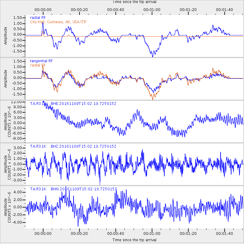
R31K City Hall, Gustavus, AK, USA - Earthquake Result Viewer
*The percent match for this event was below the threshold and hence no stack was calculated.
| Earthquake location: |
Bismarck Sea |
| Earthquake latitude/longitude: |
-4.7/149.9 |
| Earthquake time(UTC): |
2016/11/09 (314) 14:50:59 GMT |
| Earthquake Depth: |
446 km |
| Earthquake Magnitude: |
5.9 MWB |
| Earthquake Catalog/Contributor: |
NEIC PDE/NEIC COMCAT |
|
| Network: |
TA USArray Transportable Network (new EarthScope stations) |
| Station: |
R31K City Hall, Gustavus, AK, USA |
| Lat/Lon: |
58.41 N/135.74 W |
| Elevation: |
15 m |
|
| Distance: |
85.9 deg |
| Az: |
30.549 deg |
| Baz: |
254.243 deg |
| Ray Param: |
$rayparam |
*The percent match for this event was below the threshold and hence was not used in the summary stack. |
|
| Radial Match: |
21.64394 % |
| Radial Bump: |
400 |
| Transverse Match: |
22.160698 % |
| Transverse Bump: |
400 |
| SOD ConfigId: |
11737051 |
| Insert Time: |
2019-04-26 00:42:22.064 +0000 |
| GWidth: |
2.5 |
| Max Bumps: |
400 |
| Tol: |
0.001 |
|
Signal To Noise
| Channel | StoN | STA | LTA |
| TA:R31K: :BHZ:20161109T15:02:19.725015Z | 1.3607107 | 1.2003605E-6 | 8.8215705E-7 |
| TA:R31K: :BHN:20161109T15:02:19.725015Z | 1.1044296 | 1.922345E-6 | 1.7405772E-6 |
| TA:R31K: :BHE:20161109T15:02:19.725015Z | 0.95175785 | 3.944835E-6 | 4.1447884E-6 |
| Arrivals |
| Ps | |
| PpPs | |
| PsPs/PpSs | |


