You are here: Home > Network List > BK - Berkeley Digital Seismograph Network Stations List
> Station KCC Kaiser Creek, CA > Earthquake Result Viewer
KCC Kaiser Creek, CA - Earthquake Result Viewer
| Earthquake location: |
Hokkaido, Japan Region |
| Earthquake latitude/longitude: |
42.1/144.3 |
| Earthquake time(UTC): |
2004/11/11 (316) 10:02:47 GMT |
| Earthquake Depth: |
33 km |
| Earthquake Magnitude: |
5.9 MB, 6.0 MS, 6.1 MW, 6.1 MW |
| Earthquake Catalog/Contributor: |
WHDF/NEIC |
|
| Network: |
BK Berkeley Digital Seismograph Network |
| Station: |
KCC Kaiser Creek, CA |
| Lat/Lon: |
37.32 N/119.32 W |
| Elevation: |
888 m |
|
| Distance: |
70.2 deg |
| Az: |
57.341 deg |
| Baz: |
308.235 deg |
| Ray Param: |
0.055066325 |
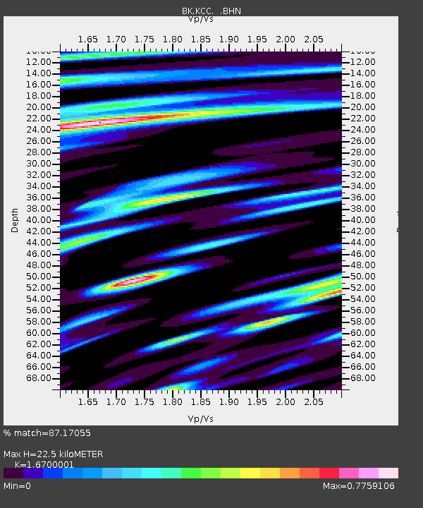
| Estimated Moho Depth: |
22.5 km |
| Estimated Crust Vp/Vs: |
1.67 |
| Assumed Crust Vp: |
6.291 km/s |
| Estimated Crust Vs: |
3.767 km/s |
| Estimated Crust Poisson's Ratio: |
0.22 |
|
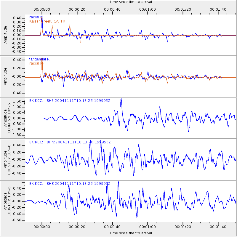
| Radial Match: |
87.17055 % |
| Radial Bump: |
400 |
| Transverse Match: |
80.305214 % |
| Transverse Bump: |
400 |
| SOD ConfigId: |
124340 |
| Insert Time: |
2010-03-05 19:32:47.742 +0000 |
| GWidth: |
2.5 |
| Max Bumps: |
400 |
| Tol: |
0.001 |
|
Signal To Noise
| Channel | StoN | STA | LTA |
| BK:KCC: :BHN:20041111T10:13:26.199995Z | 0.6750808 | 5.4009572E-8 | 8.000461E-8 |
| BK:KCC: :BHE:20041111T10:13:26.199995Z | 0.5823348 | 3.238411E-8 | 5.5610816E-8 |
| BK:KCC: :BHZ:20041111T10:13:26.199995Z | 0.68651485 | 8.941537E-8 | 1.3024535E-7 |
| Arrivals |
| Ps | 2.5 SECOND |
| PpPs | 9.2 SECOND |
| PsPs/PpSs | 12 SECOND |


