You are here: Home > Network List > BK - Berkeley Digital Seismograph Network Stations List
> Station KCC Kaiser Creek, CA > Earthquake Result Viewer
KCC Kaiser Creek, CA - Earthquake Result Viewer
| Earthquake location: |
Tonga Islands Region |
| Earthquake latitude/longitude: |
-22.7/-175.2 |
| Earthquake time(UTC): |
2004/09/13 (257) 22:29:30 GMT |
| Earthquake Depth: |
10 km |
| Earthquake Magnitude: |
5.2 MB, 5.4 MS, 5.6 MW |
| Earthquake Catalog/Contributor: |
WHDF/NEIC |
|
| Network: |
BK Berkeley Digital Seismograph Network |
| Station: |
KCC Kaiser Creek, CA |
| Lat/Lon: |
37.32 N/119.32 W |
| Elevation: |
888 m |
|
| Distance: |
79.5 deg |
| Az: |
42.157 deg |
| Baz: |
231.048 deg |
| Ray Param: |
0.04889546 |
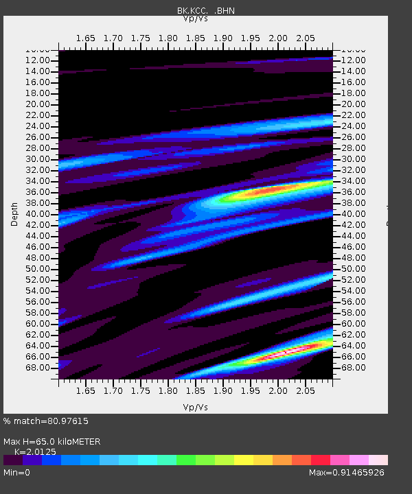
| Estimated Moho Depth: |
65.0 km |
| Estimated Crust Vp/Vs: |
2.01 |
| Assumed Crust Vp: |
6.291 km/s |
| Estimated Crust Vs: |
3.126 km/s |
| Estimated Crust Poisson's Ratio: |
0.34 |
|
| Radial Match: |
80.97615 % |
| Radial Bump: |
374 |
| Transverse Match: |
75.48455 % |
| Transverse Bump: |
385 |
| SOD ConfigId: |
124340 |
| Insert Time: |
2010-03-05 19:32:52.975 +0000 |
| GWidth: |
2.5 |
| Max Bumps: |
400 |
| Tol: |
0.001 |
|
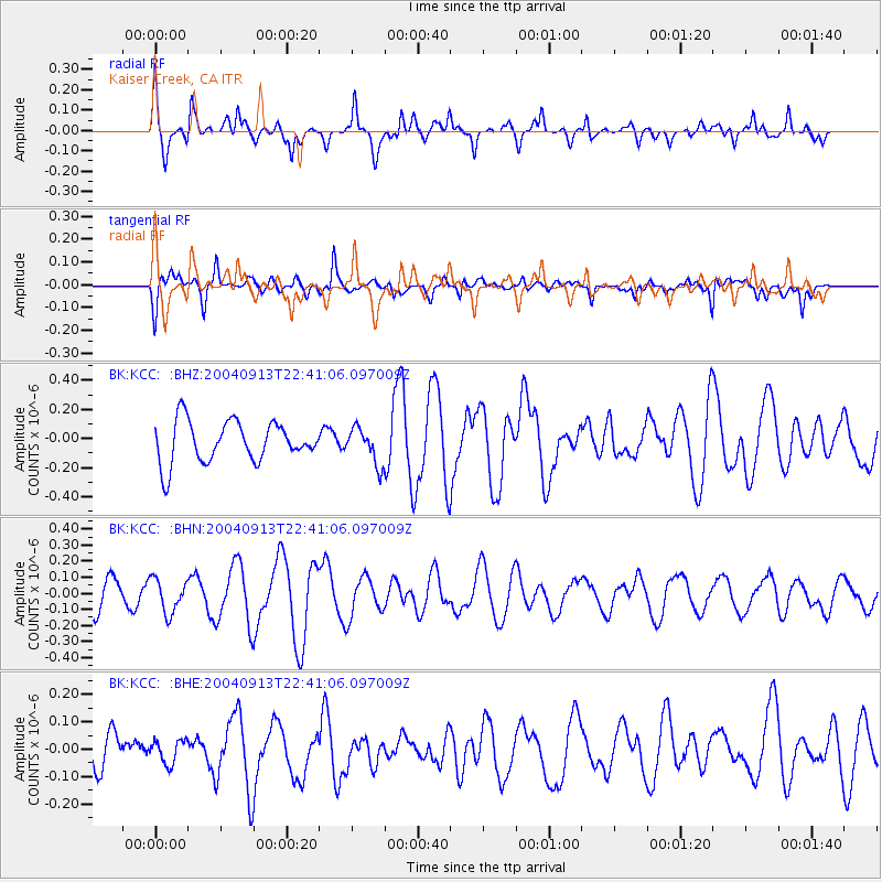
Signal To Noise
| Channel | StoN | STA | LTA |
| BK:KCC: :BHN:20040913T22:41:06.097009Z | 0.950845 | 1.0482736E-7 | 1.10246525E-7 |
| BK:KCC: :BHE:20040913T22:41:06.097009Z | 0.6238471 | 4.2856573E-8 | 6.869724E-8 |
| BK:KCC: :BHZ:20040913T22:41:06.097009Z | 0.8907887 | 1.2491583E-7 | 1.402306E-7 |
| Arrivals |
| Ps | 11 SECOND |
| PpPs | 30 SECOND |
| PsPs/PpSs | 41 SECOND |


