You are here: Home > Network List > BK - Berkeley Digital Seismograph Network Stations List
> Station KCC Kaiser Creek, CA > Earthquake Result Viewer
KCC Kaiser Creek, CA - Earthquake Result Viewer
| Earthquake location: |
Tonga Islands |
| Earthquake latitude/longitude: |
-15.2/-173.4 |
| Earthquake time(UTC): |
2004/09/08 (252) 11:00:18 GMT |
| Earthquake Depth: |
13 km |
| Earthquake Magnitude: |
5.6 MB, 5.6 MS, 5.9 MW, 5.8 MW |
| Earthquake Catalog/Contributor: |
WHDF/NEIC |
|
| Network: |
BK Berkeley Digital Seismograph Network |
| Station: |
KCC Kaiser Creek, CA |
| Lat/Lon: |
37.32 N/119.32 W |
| Elevation: |
888 m |
|
| Distance: |
72.9 deg |
| Az: |
42.516 deg |
| Baz: |
234.948 deg |
| Ray Param: |
0.053368337 |
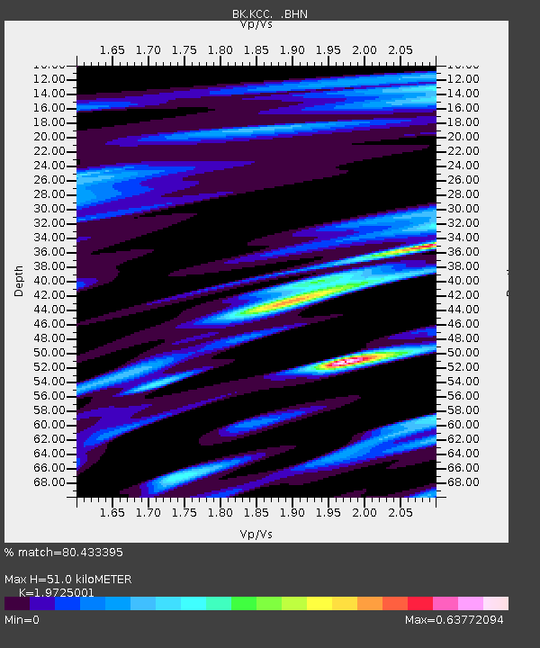
| Estimated Moho Depth: |
51.0 km |
| Estimated Crust Vp/Vs: |
1.97 |
| Assumed Crust Vp: |
6.291 km/s |
| Estimated Crust Vs: |
3.189 km/s |
| Estimated Crust Poisson's Ratio: |
0.33 |
|
| Radial Match: |
80.433395 % |
| Radial Bump: |
382 |
| Transverse Match: |
68.16123 % |
| Transverse Bump: |
400 |
| SOD ConfigId: |
124340 |
| Insert Time: |
2010-03-05 19:32:55.779 +0000 |
| GWidth: |
2.5 |
| Max Bumps: |
400 |
| Tol: |
0.001 |
|
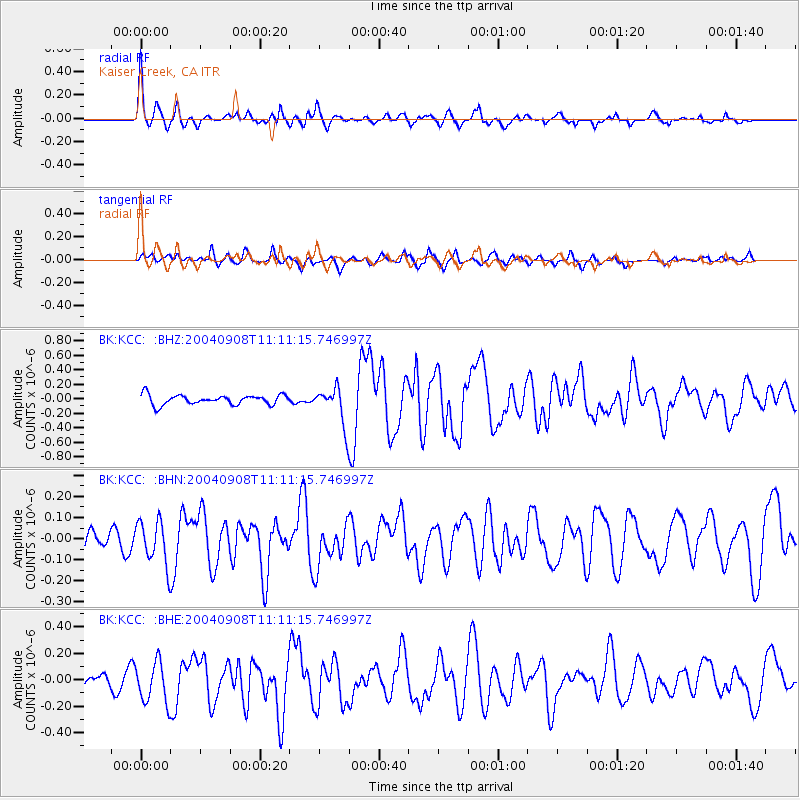
Signal To Noise
| Channel | StoN | STA | LTA |
| BK:KCC: :BHN:20040908T11:11:15.746997Z | 1.8649242 | 1.0317615E-7 | 5.532458E-8 |
| BK:KCC: :BHE:20040908T11:11:15.746997Z | 4.178856 | 1.5465974E-7 | 3.7010068E-8 |
| BK:KCC: :BHZ:20040908T11:11:15.746997Z | 3.9471111 | 2.6395506E-7 | 6.687297E-8 |
| Arrivals |
| Ps | 8.1 SECOND |
| PpPs | 23 SECOND |
| PsPs/PpSs | 32 SECOND |


