You are here: Home > Network List > BK - Berkeley Digital Seismograph Network Stations List
> Station KCC Kaiser Creek, CA > Earthquake Result Viewer
KCC Kaiser Creek, CA - Earthquake Result Viewer
| Earthquake location: |
Mariana Islands |
| Earthquake latitude/longitude: |
14.5/147.0 |
| Earthquake time(UTC): |
2004/10/04 (278) 19:20:34 GMT |
| Earthquake Depth: |
7.2 km |
| Earthquake Magnitude: |
5.9 MB, 5.9 MS, 6.0 MW, 5.9 MW |
| Earthquake Catalog/Contributor: |
WHDF/NEIC |
|
| Network: |
BK Berkeley Digital Seismograph Network |
| Station: |
KCC Kaiser Creek, CA |
| Lat/Lon: |
37.32 N/119.32 W |
| Elevation: |
888 m |
|
| Distance: |
84.2 deg |
| Az: |
53.094 deg |
| Baz: |
283.756 deg |
| Ray Param: |
0.04565436 |
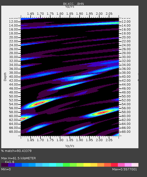
| Estimated Moho Depth: |
61.5 km |
| Estimated Crust Vp/Vs: |
1.60 |
| Assumed Crust Vp: |
6.291 km/s |
| Estimated Crust Vs: |
3.932 km/s |
| Estimated Crust Poisson's Ratio: |
0.18 |
|
| Radial Match: |
90.43379 % |
| Radial Bump: |
400 |
| Transverse Match: |
84.60739 % |
| Transverse Bump: |
400 |
| SOD ConfigId: |
2459 |
| Insert Time: |
2010-03-05 19:32:59.814 +0000 |
| GWidth: |
2.5 |
| Max Bumps: |
400 |
| Tol: |
0.001 |
|
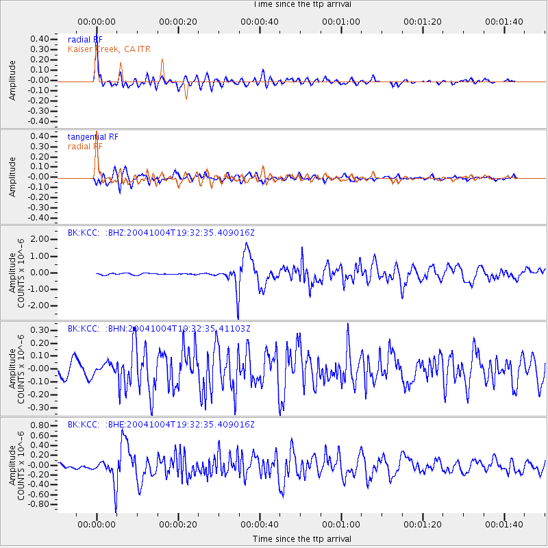
Signal To Noise
| Channel | StoN | STA | LTA |
| BK:KCC: :BHN:20041004T19:32:35.41103Z | 0.4765045 | 3.7683808E-8 | 7.908384E-8 |
| BK:KCC: :BHE:20041004T19:32:35.409016Z | 6.2645 | 2.6912602E-7 | 4.296049E-8 |
| BK:KCC: :BHZ:20041004T19:32:35.409016Z | 16.930042 | 7.458009E-7 | 4.4051923E-8 |
| Arrivals |
| Ps | 6.0 SECOND |
| PpPs | 25 SECOND |
| PsPs/PpSs | 31 SECOND |


