You are here: Home > Network List > BK - Berkeley Digital Seismograph Network Stations List
> Station KCC Kaiser Creek, CA > Earthquake Result Viewer
KCC Kaiser Creek, CA - Earthquake Result Viewer
| Earthquake location: |
Kuril Islands |
| Earthquake latitude/longitude: |
47.1/154.4 |
| Earthquake time(UTC): |
2006/11/15 (319) 12:16:05 GMT |
| Earthquake Depth: |
10 km |
| Earthquake Magnitude: |
5.7 MB |
| Earthquake Catalog/Contributor: |
WHDF/NEIC |
|
| Network: |
BK Berkeley Digital Seismograph Network |
| Station: |
KCC Kaiser Creek, CA |
| Lat/Lon: |
37.32 N/119.32 W |
| Elevation: |
888 m |
|
| Distance: |
61.5 deg |
| Az: |
64.794 deg |
| Baz: |
309.175 deg |
| Ray Param: |
0.06080421 |
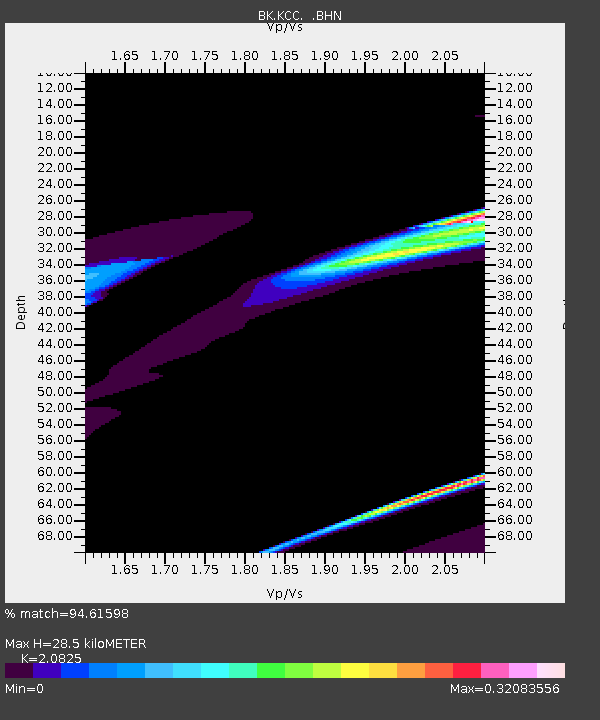
| Estimated Moho Depth: |
28.5 km |
| Estimated Crust Vp/Vs: |
2.08 |
| Assumed Crust Vp: |
6.291 km/s |
| Estimated Crust Vs: |
3.021 km/s |
| Estimated Crust Poisson's Ratio: |
0.35 |
|
| Radial Match: |
94.61598 % |
| Radial Bump: |
356 |
| Transverse Match: |
84.71178 % |
| Transverse Bump: |
393 |
| SOD ConfigId: |
2564 |
| Insert Time: |
2010-03-05 19:33:12.667 +0000 |
| GWidth: |
2.5 |
| Max Bumps: |
400 |
| Tol: |
0.001 |
|
Signal To Noise
| Channel | StoN | STA | LTA |
| BK:KCC: :BHN:20061115T12:25:51.597007Z | 2.8857954 | 2.3675355E-5 | 8.204101E-6 |
| BK:KCC: :BHE:20061115T12:25:51.597007Z | 1.3175206 | 1.2568072E-5 | 9.539183E-6 |
| BK:KCC: :BHZ:20061115T12:25:51.597007Z | 1.0075157 | 2.390634E-5 | 2.3728006E-5 |
| Arrivals |
| Ps | 5.1 SECOND |
| PpPs | 13 SECOND |
| PsPs/PpSs | 19 SECOND |


