You are here: Home > Network List > BK - Berkeley Digital Seismograph Network Stations List
> Station KCC Kaiser Creek, CA > Earthquake Result Viewer
KCC Kaiser Creek, CA - Earthquake Result Viewer
| Earthquake location: |
Kuril Islands |
| Earthquake latitude/longitude: |
46.6/153.3 |
| Earthquake time(UTC): |
2006/11/15 (319) 11:14:13 GMT |
| Earthquake Depth: |
10 km |
| Earthquake Magnitude: |
6.5 MB, 7.8 MS, 8.3 MW, 7.9 MW |
| Earthquake Catalog/Contributor: |
WHDF/NEIC |
|
| Network: |
BK Berkeley Digital Seismograph Network |
| Station: |
KCC Kaiser Creek, CA |
| Lat/Lon: |
37.32 N/119.32 W |
| Elevation: |
888 m |
|
| Distance: |
62.5 deg |
| Az: |
63.89 deg |
| Baz: |
309.032 deg |
| Ray Param: |
0.06019598 |
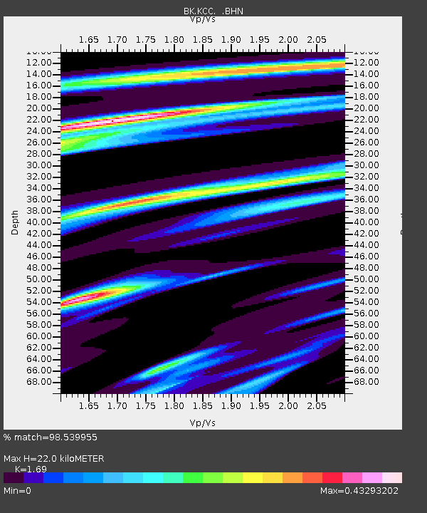
| Estimated Moho Depth: |
22.0 km |
| Estimated Crust Vp/Vs: |
1.69 |
| Assumed Crust Vp: |
6.291 km/s |
| Estimated Crust Vs: |
3.723 km/s |
| Estimated Crust Poisson's Ratio: |
0.23 |
|
| Radial Match: |
98.539955 % |
| Radial Bump: |
243 |
| Transverse Match: |
94.78628 % |
| Transverse Bump: |
400 |
| SOD ConfigId: |
2564 |
| Insert Time: |
2010-03-05 19:33:14.098 +0000 |
| GWidth: |
2.5 |
| Max Bumps: |
400 |
| Tol: |
0.001 |
|
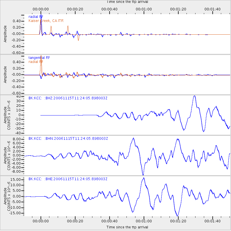
Signal To Noise
| Channel | StoN | STA | LTA |
| BK:KCC: :BHN:20061115T11:24:05.898003Z | 3.0991058 | 3.657424E-7 | 1.18015464E-7 |
| BK:KCC: :BHE:20061115T11:24:05.898003Z | 5.032627 | 5.1973547E-7 | 1.032732E-7 |
| BK:KCC: :BHZ:20061115T11:24:05.898003Z | 7.233801 | 1.3950088E-6 | 1.9284589E-7 |
| Arrivals |
| Ps | 2.5 SECOND |
| PpPs | 9.0 SECOND |
| PsPs/PpSs | 12 SECOND |


