You are here: Home > Network List > BK - Berkeley Digital Seismograph Network Stations List
> Station KCC Kaiser Creek, CA > Earthquake Result Viewer
KCC Kaiser Creek, CA - Earthquake Result Viewer
| Earthquake location: |
Chile-Argentina Border Region |
| Earthquake latitude/longitude: |
-24.4/-67.0 |
| Earthquake time(UTC): |
2006/08/25 (237) 00:44:46 GMT |
| Earthquake Depth: |
184 km |
| Earthquake Magnitude: |
5.9 MB, 6.6 MW, 6.6 MW |
| Earthquake Catalog/Contributor: |
WHDF/NEIC |
|
| Network: |
BK Berkeley Digital Seismograph Network |
| Station: |
KCC Kaiser Creek, CA |
| Lat/Lon: |
37.32 N/119.32 W |
| Elevation: |
888 m |
|
| Distance: |
78.7 deg |
| Az: |
319.969 deg |
| Baz: |
132.643 deg |
| Ray Param: |
0.04902501 |
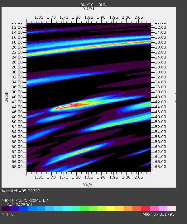
| Estimated Moho Depth: |
43.75 km |
| Estimated Crust Vp/Vs: |
1.75 |
| Assumed Crust Vp: |
6.291 km/s |
| Estimated Crust Vs: |
3.6 km/s |
| Estimated Crust Poisson's Ratio: |
0.26 |
|
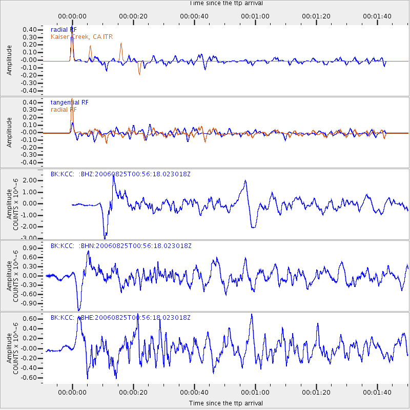
| Radial Match: |
85.09799 % |
| Radial Bump: |
400 |
| Transverse Match: |
73.91425 % |
| Transverse Bump: |
400 |
| SOD ConfigId: |
2665 |
| Insert Time: |
2010-03-05 19:33:31.578 +0000 |
| GWidth: |
2.5 |
| Max Bumps: |
400 |
| Tol: |
0.001 |
|
Signal To Noise
| Channel | StoN | STA | LTA |
| BK:KCC: :BHN:20060825T00:56:18.023018Z | 24.066538 | 5.202128E-7 | 2.1615605E-8 |
| BK:KCC: :BHE:20060825T00:56:18.023018Z | 31.95613 | 3.6168635E-7 | 1.1318216E-8 |
| BK:KCC: :BHZ:20060825T00:56:18.023018Z | 36.721756 | 1.4213848E-6 | 3.8706887E-8 |
| Arrivals |
| Ps | 5.3 SECOND |
| PpPs | 19 SECOND |
| PsPs/PpSs | 24 SECOND |


