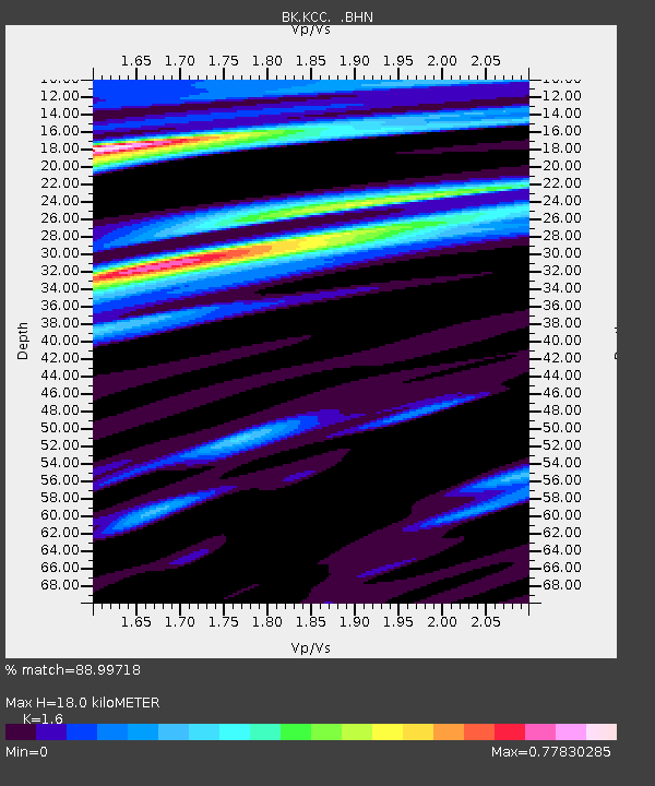
KCC Kaiser Creek, CA - Earthquake Result Viewer
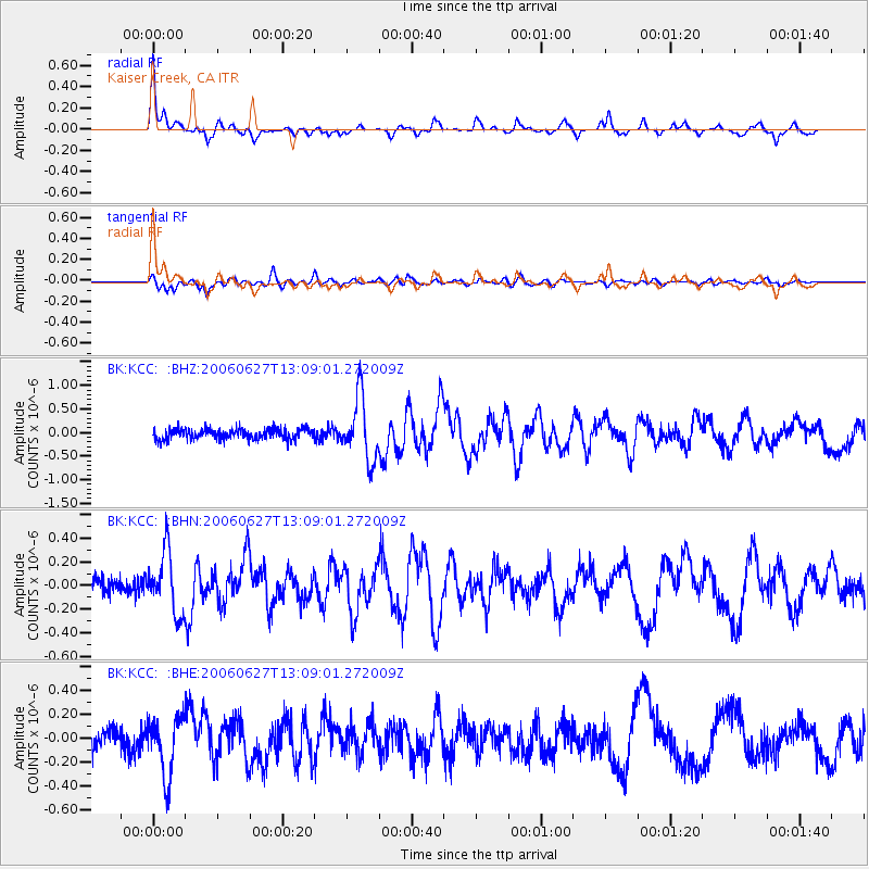
Earthquake location: Off Coast Of Chiapas, Mexico
Earthquake latitude/longitude: 15.0/-94.2
Earthquake time(UTC): 2006/06/27 (178) 13:03:12 GMT
Earthquake Depth: 29 km
Earthquake Magnitude: 5.4 MB, 5.5 MS, 5.8 MW, 5.8 MW
Earthquake Catalog/Contributor: WHDF/NEIC
Network: BK Berkeley Digital Seismograph Network
Station: KCC Kaiser Creek, CA
Lat/Lon: 37.32 N/119.32 W
Elevation: 888 m
Distance: 31.5 deg
Az: 319.635 deg
Baz: 128.257 deg
Ray Param: 0.07899913
Estimated Moho Depth: 18.0 km
Estimated Crust Vp/Vs: 1.60
Assumed Crust Vp: 6.291 km/s
Estimated Crust Vs: 3.932 km/s
Estimated Crust Poisson's Ratio: 0.18
Radial Match: 88.99718 %
Radial Bump: 324
Transverse Match: 82.96551 %
Transverse Bump: 400
SOD ConfigId: 2665
Insert Time: 2010-03-05 19:33:46.159 +0000
GWidth: 2.5
Max Bumps: 400
Tol: 0.001

Signal To Noise

ChannelStoNSTALTA
BK:KCC: :BHN:20060627T13:09:01.272009Z3.65794732.5665588E-77.016391E-8
BK:KCC: :BHE:20060627T13:09:01.272009Z3.0762492.4529558E-77.973854E-8
BK:KCC: :BHZ:20060627T13:09:01.272009Z6.0157266.5692745E-71.09201686E-7
Arrivals
Ps1.9 SECOND
PpPs6.8 SECOND
PsPs/PpSs8.7 SECOND