You are here: Home > Network List > BK - Berkeley Digital Seismograph Network Stations List
> Station KCC Kaiser Creek, CA > Earthquake Result Viewer
KCC Kaiser Creek, CA - Earthquake Result Viewer
| Earthquake location: |
Tonga Islands |
| Earthquake latitude/longitude: |
-20.2/-174.1 |
| Earthquake time(UTC): |
2006/05/03 (123) 15:26:40 GMT |
| Earthquake Depth: |
55 km |
| Earthquake Magnitude: |
7.2 MB, 7.8 MS, 7.9 MW, 7.9 MW |
| Earthquake Catalog/Contributor: |
WHDF/NEIC |
|
| Network: |
BK Berkeley Digital Seismograph Network |
| Station: |
KCC Kaiser Creek, CA |
| Lat/Lon: |
37.32 N/119.32 W |
| Elevation: |
888 m |
|
| Distance: |
77.0 deg |
| Az: |
41.952 deg |
| Baz: |
231.971 deg |
| Ray Param: |
0.05049462 |
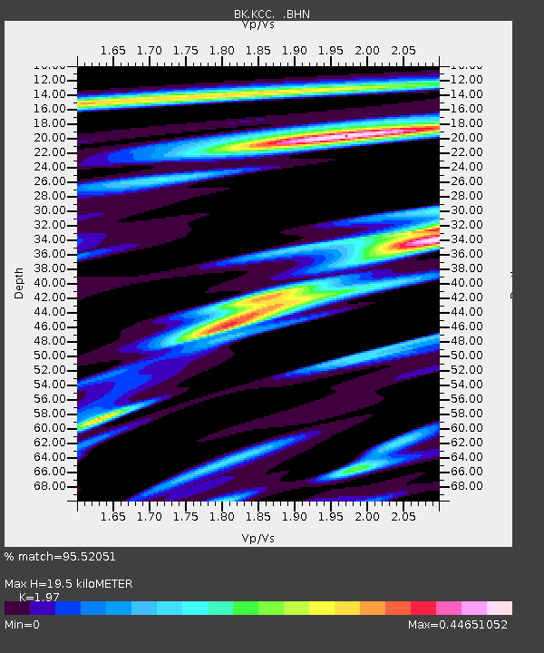
| Estimated Moho Depth: |
19.5 km |
| Estimated Crust Vp/Vs: |
1.97 |
| Assumed Crust Vp: |
6.291 km/s |
| Estimated Crust Vs: |
3.194 km/s |
| Estimated Crust Poisson's Ratio: |
0.33 |
|
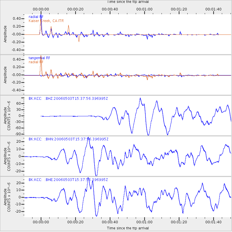
| Radial Match: |
95.52051 % |
| Radial Bump: |
323 |
| Transverse Match: |
89.555916 % |
| Transverse Bump: |
400 |
| SOD ConfigId: |
2669 |
| Insert Time: |
2010-03-05 19:33:50.668 +0000 |
| GWidth: |
2.5 |
| Max Bumps: |
400 |
| Tol: |
0.001 |
|
Signal To Noise
| Channel | StoN | STA | LTA |
| BK:KCC: :BHN:20060503T15:37:56.396995Z | 2.3270996 | 4.1835054E-7 | 1.7977338E-7 |
| BK:KCC: :BHE:20060503T15:37:56.396995Z | 2.2033145 | 6.3026823E-7 | 2.8605456E-7 |
| BK:KCC: :BHZ:20060503T15:37:56.396995Z | 3.9805436 | 1.8325587E-6 | 4.60379E-7 |
| Arrivals |
| Ps | 3.1 SECOND |
| PpPs | 9.0 SECOND |
| PsPs/PpSs | 12 SECOND |


