You are here: Home > Network List > CI - Caltech Regional Seismic Network Stations List
> Station MPP McPhearson Peak > Earthquake Result Viewer
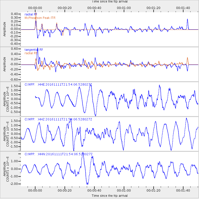
MPP McPhearson Peak - Earthquake Result Viewer
*The percent match for this event was below the threshold and hence no stack was calculated.
| Earthquake location: |
Near East Coast Of Honshu, Japan |
| Earthquake latitude/longitude: |
38.5/141.6 |
| Earthquake time(UTC): |
2016/11/11 (316) 21:42:59 GMT |
| Earthquake Depth: |
45 km |
| Earthquake Magnitude: |
6.2 MWB |
| Earthquake Catalog/Contributor: |
NEIC PDE/NEIC COMCAT |
|
| Network: |
CI Caltech Regional Seismic Network |
| Station: |
MPP McPhearson Peak |
| Lat/Lon: |
34.89 N/119.81 W |
| Elevation: |
1739 m |
|
| Distance: |
75.2 deg |
| Az: |
57.229 deg |
| Baz: |
306.624 deg |
| Ray Param: |
$rayparam |
*The percent match for this event was below the threshold and hence was not used in the summary stack. |
|
| Radial Match: |
66.01436 % |
| Radial Bump: |
400 |
| Transverse Match: |
52.36087 % |
| Transverse Bump: |
400 |
| SOD ConfigId: |
11737051 |
| Insert Time: |
2019-04-26 00:53:36.778 +0000 |
| GWidth: |
2.5 |
| Max Bumps: |
400 |
| Tol: |
0.001 |
|
Signal To Noise
| Channel | StoN | STA | LTA |
| CI:MPP: :HHZ:20161111T21:54:06.528027Z | 2.1751206 | 8.1197027E-7 | 3.7329897E-7 |
| CI:MPP: :HHN:20161111T21:54:06.528027Z | 0.6782325 | 4.5971785E-7 | 6.778175E-7 |
| CI:MPP: :HHE:20161111T21:54:06.528027Z | 1.9329574 | 1.1000353E-6 | 5.690944E-7 |
| Arrivals |
| Ps | |
| PpPs | |
| PsPs/PpSs | |


