You are here: Home > Network List > BK - Berkeley Digital Seismograph Network Stations List
> Station KCC Kaiser Creek, CA > Earthquake Result Viewer
KCC Kaiser Creek, CA - Earthquake Result Viewer
| Earthquake location: |
Central East Pacific Rise |
| Earthquake latitude/longitude: |
-13.4/-112.2 |
| Earthquake time(UTC): |
2004/08/01 (214) 19:44:47 GMT |
| Earthquake Depth: |
10 km |
| Earthquake Magnitude: |
5.1 MB, 5.6 MS |
| Earthquake Catalog/Contributor: |
WHDF/NEIC |
|
| Network: |
BK Berkeley Digital Seismograph Network |
| Station: |
KCC Kaiser Creek, CA |
| Lat/Lon: |
37.32 N/119.32 W |
| Elevation: |
888 m |
|
| Distance: |
50.9 deg |
| Az: |
352.695 deg |
| Baz: |
171.07 deg |
| Ray Param: |
0.067762196 |
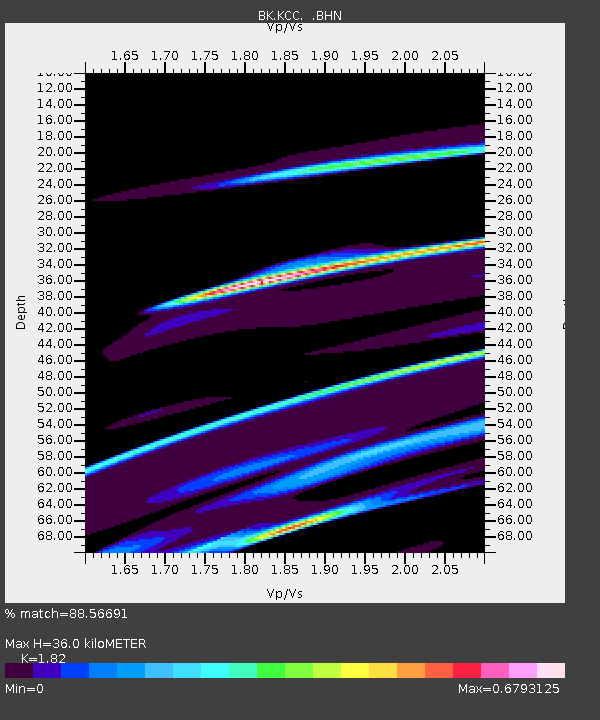
| Estimated Moho Depth: |
36.0 km |
| Estimated Crust Vp/Vs: |
1.82 |
| Assumed Crust Vp: |
6.291 km/s |
| Estimated Crust Vs: |
3.457 km/s |
| Estimated Crust Poisson's Ratio: |
0.28 |
|
| Radial Match: |
88.56691 % |
| Radial Bump: |
354 |
| Transverse Match: |
78.203224 % |
| Transverse Bump: |
400 |
| SOD ConfigId: |
124340 |
| Insert Time: |
2010-03-05 19:33:55.391 +0000 |
| GWidth: |
2.5 |
| Max Bumps: |
400 |
| Tol: |
0.001 |
|
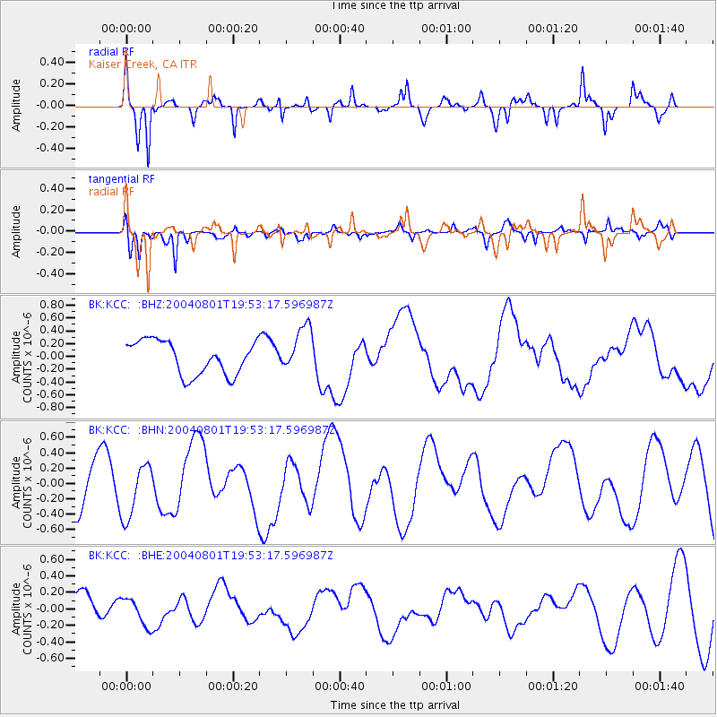
Signal To Noise
| Channel | StoN | STA | LTA |
| BK:KCC: :BHN:20040801T19:53:17.596987Z | 0.98477024 | 3.434855E-7 | 3.487976E-7 |
| BK:KCC: :BHE:20040801T19:53:17.596987Z | 0.88008213 | 1.6578383E-7 | 1.8837314E-7 |
| BK:KCC: :BHZ:20040801T19:53:17.596987Z | 1.3837943 | 3.6070796E-7 | 2.6066587E-7 |
| Arrivals |
| Ps | 4.9 SECOND |
| PpPs | 15 SECOND |
| PsPs/PpSs | 20 SECOND |


