You are here: Home > Network List > BK - Berkeley Digital Seismograph Network Stations List
> Station KCC Kaiser Creek, CA > Earthquake Result Viewer
KCC Kaiser Creek, CA - Earthquake Result Viewer
| Earthquake location: |
Solomon Islands |
| Earthquake latitude/longitude: |
-11.1/162.2 |
| Earthquake time(UTC): |
2004/11/11 (316) 17:34:52 GMT |
| Earthquake Depth: |
10 km |
| Earthquake Magnitude: |
5.8 MB, 6.6 MS, 6.7 MW, 6.6 MW |
| Earthquake Catalog/Contributor: |
WHDF/NEIC |
|
| Network: |
BK Berkeley Digital Seismograph Network |
| Station: |
KCC Kaiser Creek, CA |
| Lat/Lon: |
37.32 N/119.32 W |
| Elevation: |
888 m |
|
| Distance: |
87.7 deg |
| Az: |
51.421 deg |
| Baz: |
254.247 deg |
| Ray Param: |
0.043153826 |
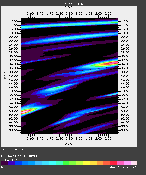
| Estimated Moho Depth: |
58.25 km |
| Estimated Crust Vp/Vs: |
1.62 |
| Assumed Crust Vp: |
6.291 km/s |
| Estimated Crust Vs: |
3.896 km/s |
| Estimated Crust Poisson's Ratio: |
0.19 |
|
| Radial Match: |
86.25085 % |
| Radial Bump: |
400 |
| Transverse Match: |
79.99446 % |
| Transverse Bump: |
400 |
| SOD ConfigId: |
2459 |
| Insert Time: |
2010-03-05 19:34:06.316 +0000 |
| GWidth: |
2.5 |
| Max Bumps: |
400 |
| Tol: |
0.001 |
|
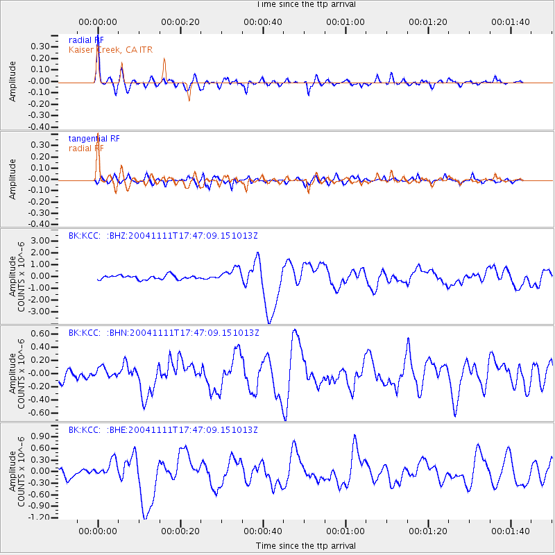
Signal To Noise
| Channel | StoN | STA | LTA |
| BK:KCC: :BHN:20041111T17:47:09.151013Z | 0.6892238 | 7.842435E-8 | 1.1378648E-7 |
| BK:KCC: :BHE:20041111T17:47:09.151013Z | 2.121238 | 2.2892493E-7 | 1.07920435E-7 |
| BK:KCC: :BHZ:20041111T17:47:09.151013Z | 3.3044367 | 5.7996425E-7 | 1.7551078E-7 |
| Arrivals |
| Ps | 5.8 SECOND |
| PpPs | 24 SECOND |
| PsPs/PpSs | 29 SECOND |


