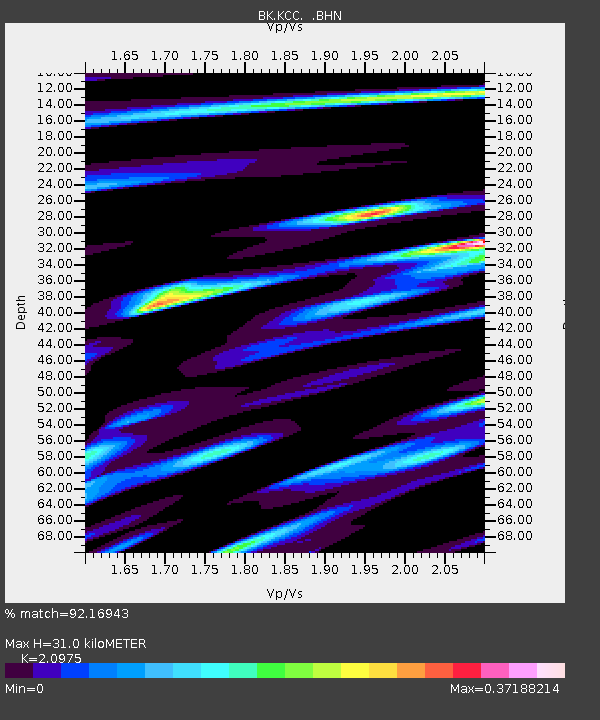
KCC Kaiser Creek, CA - Earthquake Result Viewer
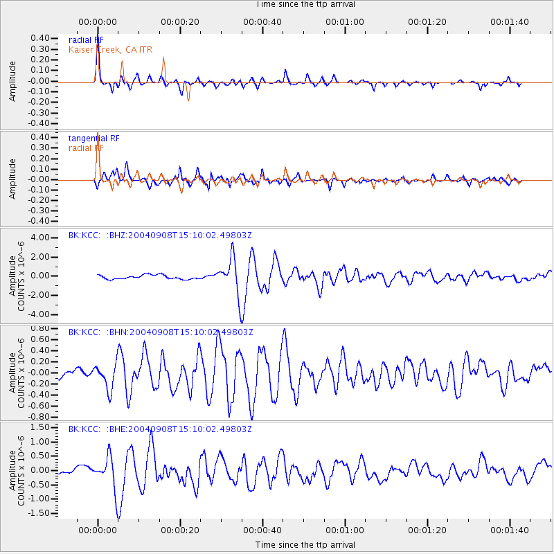
Earthquake location: Near S. Coast Of Honshu, Japan
Earthquake latitude/longitude: 33.1/137.2
Earthquake time(UTC): 2004/09/08 (252) 14:58:25 GMT
Earthquake Depth: 21 km
Earthquake Magnitude: 6.2 MB, 5.8 MS, 6.2 MW, 6.1 MW
Earthquake Catalog/Contributor: WHDF/NEIC
Network: BK Berkeley Digital Seismograph Network
Station: KCC Kaiser Creek, CA
Lat/Lon: 37.32 N/119.32 W
Elevation: 888 m
Distance: 80.1 deg
Az: 51.908 deg
Baz: 304.073 deg
Ray Param: 0.04851269
Estimated Moho Depth: 31.0 km
Estimated Crust Vp/Vs: 2.10
Assumed Crust Vp: 6.291 km/s
Estimated Crust Vs: 2.999 km/s
Estimated Crust Poisson's Ratio: 0.35
Radial Match: 92.16943 %
Radial Bump: 361
Transverse Match: 91.12953 %
Transverse Bump: 400
SOD ConfigId: 2459
Insert Time: 2010-03-05 19:34:13.312 +0000
GWidth: 2.5
Max Bumps: 400
Tol: 0.001

Signal To Noise

ChannelStoNSTALTA
BK:KCC: :BHN:20040908T15:10:02.49803Z2.34570982.3240881E-79.907824E-8
BK:KCC: :BHE:20040908T15:10:02.49803Z4.92306235.9380574E-71.2061714E-7
BK:KCC: :BHZ:20040908T15:10:02.49803Z9.1697991.9828428E-62.1623623E-7
Arrivals
Ps5.5 SECOND
PpPs15 SECOND
PsPs/PpSs20 SECOND